This review of Exhibit 9 was posted as “Part 6 – The Buache Map, Exhibit 9, Fingerprints of the Gods (long Post).” on May 9, 1996 to sci.archaeology. I have edited the original post for spelling and conversion to HTML format.
Introduction – The Problem
A major thesis of Fingerprints of the Gods (FOG), by Mr. Graham Hancock, and its explanation of why artifacts and remains of his hypothetical civilization are lacking is that this civilization occupied Antarctica when it was warm and temperate. Later, FOG claims that this civilization was buried beneath a couple of miles of ice when an abrupt crustal movement moved Antarctica into the Antarctic circle.
Talking about this idea as advocated by Rand and Rose Flem-Ath in their book When the Sky Fell, FOG claims:
1. a complete slippage of the Earth’s thirty-mile-thick crust forced large parts of the western hemisphere southward towards the equator and towards Antarctic Circle,
2. work by Hapgood (1970) shows that in the southern hemisphere, the continent of Antarctica was mostly at temperate or even warm latitudes until this crustal shift moved it completely inside the Antarctic Circle,
3. this overall crustal shift had a magnitude of 30 degrees (approximately 2000 miles or 3200 kilometers), and
4. this crustal shift occurred between 14,500 BC and 12,500 BC with “massive aftershocks on a planetary scale continuing at widely-separated intervals” until 9,500 BC.
In relation to the above claims, the Buache map mentioned in Exhibit 9 is use as evidence that Antarctica was ice free at sometime between 6,000 to 40,000 B.P.
I. Exhibit 9
In Exhibit 9, FOG very simply states:
The Buache Map, also reviewed in Part 1, accurately depicts the subglacial topography of Antarctica. (505, fn. 13)
Footnote 13 refers to Part 1 of Fingerprints of the Gods.
Then FOG rhetorically asks whether this map depicts the subglacial topography by chance or was Antarctica entirely ice-free recently enough for the cartographers of a lost civilization to have mapped it.
In Part 1, page 18, of FOG, similar claims are made without giving proof to back them up:
Buache gives us is an eerily precise representation of Antarctica as it must have looked when there was no ice on it at all (fn. 13).
Footnote 13 refers to Hapgood (1966, p. 93).
Next on page 18, FOG claims that the Buache map reveals the subglacial topography of the entire Antarctica continent which remained unknown until seismic surveys were carried out in the 1958 International Geophysical Year. In summary, FOG claims that the Buache Map shows both the subglacial (bedrock) topography and the topography of Antarctica when it was ice-free.
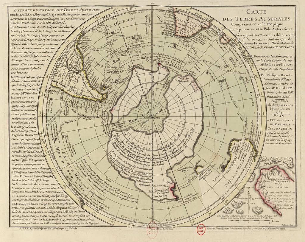
II. The Buache Map
The Buache Map is an eighteenth century map prepared by the French geographer, Philippe Buache, in 1739.
The Buache map shows two southern continents separated by an interior polar sea with two straits on either end (Hapgood 1979, Figure 53 and page 19 of FOG). The “Interior Sea” is centered on the South Pole and its axis, including one strait, lies roughly at a 90 degree angle to the north-south axis of South America. The larger of these continents forms a 220-degree arc that surrounds the Interior Sea. A large peninsula juts northward near one end. For the sake of discussion, it is called the “Large Continent.” The smaller continent, which is called the “Small Continent” lies with a flat side across the concave side of the Large Continent separated by two narrow straits and the Interior Sea from it. Except for the large peninsula of the Large Continent, the northern edge of both continents lies generally south of 50 to 55 degree south latitude.
III. Discussion
There are four major problems with the above questions and statements of FOG. First, the Buache Map fails miserably to accurately depict the subglacial topography of Antarctica. Second, although from 50 to over 700 meters of uplift as a result of isostatic rebound would have altered the subglacial topography of Antarctica when it had been ice-free, the Buache map still fails to remotely resemble a hypothetical ice-free topography of Antarctica. Third, numerous paleoclimatic and sedimentologic studies shows Antarctica was ice-covered and glaciated when Hapgood (1979) and FOG claim that it was ice-free and temperate 40,000 to 6,000 B.P. Finally, Antarctica was totally ice-free over 14 million years ago.
A. Subglacial Topography
Comparison of the Buache map of 1783 to the subglacial topography illustrated by Drewry (1983) and LeMasier and Rex (1991, Fig. 7-2), clearly demonstrates that there is little, if any resemblance between each map. The fit between the Large Continent, the Small Continent, and the Interior Sea and the subglacial topography of Antarctica is poor to nonexistent.1. The Interior Sea. The Interior Sea as shown by the Buache Map of 1783 according to the subglacial topography map of Drewry (1983) simply does not exist. The bedrock topography lying above sea level beneath East Antarctica lacks the concave “coastline” that forms the Interior Sea. Furthermore, the Buache map of 1783 shows the South Pole to be centered on the Interior Sea while the South Pole in Drewry lies well within the above sea level bedrock high beneath East Antarctica. Finally, large bedrock “islands” occur within that part of the Interior Sea which lies within parts of Antarctica that has bedrock topography lying below sea level. The well-defined waterways that FOG claims connects the Ross, Weddell, and Bellinghausen Seas simply do not exist.
Hapgood (1966, 1979) claims that the Interior Sea shown by the Buache map of 1783 is misoriented by 90 degrees. Because according the subglacial topography maps, e.g. Drewry (1983) and LeMasier and Rex (1991, Fig. 7-2) demonstrates that this sea does not exist, these claims are moot. Still, the Buache map shows the concave edge of Large Continent cutting perpendicular across the above sea level bedrock underlying East Antarctica. Hapgood (1966, 1979) characteristically attributes this major discrepancy between the Buache map and the subglacial topography map to both an “apparent error in the orientation of the continent” and the original source map being drawn with curved meridians without producing any proof or evidence for these speculations at all.2. The Small Continent. The subglacial topography map of Drewry (1983) lacks any possible equivalent to the Small Continent illustrated by the Buache map of 1783. As shown by Drewry (1983), West Antarctica is underlain by only an “archipelago” of bedrock highs that rise in elevation above sea level. In fact, three of these bedrock highs which include the Holick and Whitmore Mountains lie right where the Buache map shows part of the Interior Sea to be. They clearly obstruct the seaway that FOG falsely claims to exist.3. The Large Continent. The Large Continent of the Buache map is also a mismatch with the subglacial topography shown by Drewry (1983). The subglacial topography underlying East Antarctica fails to match the shape and size of the Large Continent. Among many mismatches, the subglacial topography beneath East Antarctica lacks the concave edge shown by Buache for the Large Continent. Also, the prominent northward extending peninsula of the Large Continent is completely absent. In fact, where Buache shows this peninsula to exist, the subglacial topography of Wilkes Land is characterized by two large subglacial basins that lie hundreds of meters below sea level and extend as much as 1500 kilometers inland from the modern shoreline. Only an “archipelago” of bedrock highs rise above sea level beneath the coastal region of Wilkes Land (Drewry 1983).
Clearly, there is absolutely no correspondence between the subglacial bed topography of Antarctica and the southern continents and interior seaway shown by the Buache map of 1783. In can only be concluded that the claims of both FOG and Hapgood (1966, 1979) that the Buache map shows the subglacial topography of Antarctica are clearly falsified by the subglacial topography shown by Drewry (1983) and LeMasier and Rex (1991, Fig. 7-2).
B. Ice-Free Topography
As previously noted, both FOG and Hapgood (1966, 1979) are unaware of isostatic rebound and depression associated with very thick ice caps. Their disregard of this fundamental principle of glaciology is illustrated by way in which they consider the subglacial topography of Antarctica to be the same as the ice-free topography of Antarctica. Many studies, e.g. Drewry (1983), Heezen et al. (1973), and Bentley and Ostenso (1961), have long recognized that the weight of the Antarctic ice cap has depressed the continental crust on which it lies as much as 700 meters within portions of West and East Antarctica to just less than 50 meters along the exposed edges.
Thus, prior to the formation of the ice cap and during any hypothetical ice-free periods, Antarctica would have been or would eventually rise by 50 to over 700 meters higher than it is now. Since the melting of the Antarctica ice-caps would have raised sea level by 66 meters (Skinner and Porter 1995), isostatic rebound eventually would more than compensate for any sea level rise within Antarctica. However, the difference between rapid sea level rise and slow isostatic rebound would for thousands of years create a shifting shoreline.
At maximum isostatic rebound, there would be several significant differences between subglacial topography and a hypothetical ice-free topography as illustrated by Drewry (1983), Heezen et al. (1973), and Bentley (1991). In case of a hypothetical ice-free Antarctica, the Palmer Peninsula would extend, interrupted only by two deep, but narrow straits, from its present location back to the Transantarctica Mountains. These mountains would form the shoreline of Antarctica. The rest of West Antarctica would remain an archipelago. As a result of isostatic rebound most of East Antarctica would be above sea level, except a prominent south-trending bay beneath Wilkes Land and a few shallow bays along its coastline. Despite these changes, the resulting coastline would still bear little, if any resemblance to the Buache map of 1783 proving the claims of FOG and Hapgood (1966, 1979) about this map again to be clearly incorrect.
C. Late Quaternary Climate of Antarctica
As previously discussed, there is an abundance of evidence that demonstrates that Antarctica was covered by a fully developed ice cap between 40,000 to 6,000 B.P. contrary to the claims of FOG and Hapgood (1966, 1979). This evidence includes ice core data (Jouzel et al 1987, Lorius et al. 1979), cores from the Ross Sea (Licht et al. 1996, Kellogg 1979), palynological data from tip of South America (Heusser 1989), and numerous radiocarbon dates from glacio-lacustrine deposits and deltas (Stuvier et al. 1981). In fact, these and other studies show that a maximum development of the ice cap and Ross Ice Shelf occurred during that period, 21,000 to 16,000 B.P. (Denton et al. 1991), which falsifies all of the claims made by FOG, “The Mysterious Origins of Man,” and Hapgood (1966, 1979) about the glacial history of Antarctica.
D. Youngest Ice-Free Period
As I have reviewed in previous posts, numerous studies, e.g. Denton et al. (1991) and Marchant et al. (1966) present an abundance of evidence that Antarctica was last completely ice-free over 14 million years ago. Deep cores and borings made into sediments filling deep basins within and thousands of kilometers of seismic data from the continental shelf of Antarctica confirm these studies (Cooper et al. 1995).
Conclusions
From the preceding discussion, it can be concluded that statements by FOG such as:
The Buache Map, also reviewed in Part 1, accurately depicts the subglacial topography of Antarctica. (505, fn. 13)
and:
Buache gives us an eerily precise representation of Antarctica as it must have looked when there was no ice on it at all. (18, fn. 13)
are completely false and have no basis in fact. Therefore, the Buache map of 1783 contrary to the claims of FOG and Hapgood (1966, 1979) fails to contain any evidence that the Antarctic was mapped when it was ice-free. Therefore, the Buache map fails as evidence of Earth crustal displacement. It should also be noted that both FOG and Hapgood (1966, 1979) are also incorrect, as demonstrated in a previous review of Exhibit 7, in claiming that Antarctica was ice-free between 40,000 to 6,000 B.P. Rather the last ice-free period was sometime before 14 million years ago.
References
Bentley, C. R., 1991, Configuration and structure of the subglacial crust. In R. T. Tingey (ed.), pp. 336-368, The Geology of Antarctica. Clarendon Press, Oxford.
Bentley, C. R., and Ostenso N. A., 1961, Glacial and subglacial topography of West Antarctica. Journal of Glaciology. vol. 3, no. 29, pp. 882-912.
Cooper, A. K., Barker, P. F., Brancolini, G. (eds.), 1995, Geology and seismic stratigraphy of the Antarctic Margin. Antarctic Research Series, vol. 68, American Geophysical Union, Washington, D.C., 303 pp.
Denton, G. H., Prentice, M. L., and Burkle, L. H., 1991, Cainozoic history of the Antarctic ice sheet. In R. T. Tingey (ed.), pp. 366-433, The Geology of Antarctica. Claredon Press, Oxford.
Drewry, D. J. (ed.), 1983, Antarctica: Glaciological and Geophysical Folio. Scott Polar Research Institute, Cambridge.
Hapgood, C. H., 1966, Maps of the Ancient Sea Kings, 1st Edition, Chilton Books, Philadelphia.
Hapgood, C. H., 1979, Maps of the Ancient Sea Kings, 2nd Edition, E. P. Dutton, New York.
Heezen, B. C., Tharp, M., and Bentley, C. R., 1973, Morphology of the Earth in the Antarctic and Subantarctic. National Geographic Society, Washington, D.C.
Heusser, C. J., 1989, Climate and chronology of Antarctica and adjacent South America over the past 30,000 years. Palaeogeography, Palaeoclimatology, Palaeoecology, vol. 76, no. 1/2, pp. 31-37.
Jouzel, S. J., Dansgaard, W., and many others, 1987, Vostok ice core: a continuous isotopic temperature record over the last climatic cycle (160,000 years). Nature. vol. 239, pp. 403-408.
LeMasier, W. E., and Rex, D. C., 1991, The Marie Byrd Land volcanic province and its relation to Cainozoic West Antarctic rift system. In R. T. Tingey (ed.), pp. 249-256, The Geology of Antarctica. Clarendon Press, Oxford.
Licht, K. J., Jennings, A. E., and others, 1996, Chronology of late Wisconsin ice retreat from the western Ross Sea, Antarctica. Geology. vol. 24, no. 3, pp. 223-226.
Lorius, C., Jouzel, S. J., and many others, 1979, A 150,000-yr isotopic climatic record from Antarctic ice. Nature, vol. 316, pp. 644-648.
Kellogg, T. B., Truesdale, R. S., and Osterman, L. E., 1979, Late Quaternary extent of the West Antarctic ice sheet: New evidence from Ross sea cores. Geology. vol. 7, pp. 249-253.
Marchant, D. R., Denton, G. H., Swisher, C. C., and Potter, N., 1996, Late Cenozoic Antarctic paleoclimate reconstructed from volcanic ashes in the Dry Valleys region of southern Victoria Land. Geological Society of America Bulletin, vol. 108, no. 2, pp. 181-194.
Skinner and Porter, 1995, Dynamic Earth, 3rd edition, John Wiley and Sons.
Stuvier, M., Denton, G. H., and others, 1981, History of marine ice sheet in Antarctica during the last glaciation: a working hypothesis. In G. H. Denton and T. J. Hughes (eds.), pp. 319- 436, The Last Great Ice Sheets. Wiley-Interscience, New York.
…..signature of post omitted…..
Version 4.0
Dec 18, 2001
Copyright (c) 1996-2002 Paul V. Heinrich All rights reserved.