Introduction
I prepared these reviews of the three Flooded Kingdoms TV broadcasts because they have been accompanied by a sequence of newspaper articles and radio broadcasts implying that the information has reached many millions of people. It is important that the views of scientists and archaeolgists who have worked on other submarine prehistoric sites should also be heard by the general public. This review is provided in the public interest, and to promote archaeology. The book “Underworld” has also been published, and I have not read it, although I have seen a copy, and received copies of several pages from web-sites. My reviews here are, nevertheless, based almost entirely on seeing the TV broadcasts and the Graham Hancock web sites.
In preparing these reviews I assume that the best part of the evidence, and the best part of the argument in favour of a presumed advanced civilisation on the continental shelf has been included in the TV broadcasts. This is a reasonable assumption. It would be unusual if the strongest evidence were not presented, given the power of the visual medium of TV.
Hancock recognises that many archaeologists brand him as “The Lunatic Fringe”, and while this is disarming, it is not in any way equivalent to identifying the evidence which actually contradicts his theories. In this third and last review I want to stress my intention of being absolutely fair to Graham Hancock throughout the series of reviews, supporting and endorsing his ideas and proposals where the bulk of modern scientific and archaeological evidence confirms his presentation, and criticising or rejecting his proposals when there is strong empirical evidence from other sources that his observations or deductions are not valid.
I do not support everything proposed by Graham Hancock in his TV programmes Flooded Kingdoms of the Ice Age, and I do not reject everything proposed by him. I do not wish the readers of this review to reach either of those over-simplified conclusions.
Agreement
On the following points proposed by Graham Hancock the bulk of scientific and archaeological data and theory agrees with his propositions:
The global sea level was about 150 metres lower during the peak of the last Ice Age, and was at its lowest about 20,000 years ago. The sea was below its present level from 100,000 to 5,000 years ago.
Human beings, and all the normal vegetation and fauna of the neighbouring land-mass, extended onto the continental shelf during the period when the sea level was lower than at present, that is roughly from 100,000 years ago to 5,000 years ago.
When the sea level rose again, while the ice caps were melting, vegetation was killed off by salination and inundated (gradually), while animals and people who had been on the continental shelf moved back onto the continents and large islands such as Japan, Sri Lanka, Tasmania, Britain and Ireland where they joined the people who had been living there anyway.
Flood myths that occur all over the world are the “folk memory” of the experience of suffering 10,000 years of (slowly) rising sea level, and the continuous loss of hunting and foraging territory.
There is a continuing need to discover, categorise, and date more prehistoric archaeological sites offshore. Work by amateur archaeologists and chance finds by trawler fishermen, scuba sports divers, and sponge divers who may recover stone tools from the seabed can be of great importance.
Differences
The allegation by Graham Hancock that the topic of people living on the continental shelf during the Ice Age has not been previously studied is incorrect. Archaeologists and geologists have in fact been studying exactly this topic since at least 1930. Hundreds of papers and books written by different experts working independently, have been published in many countries. The failure to recognise the work of these experts is derogatory to them, and results in a bias throughout the series.
Hancock refers frequently to tidal waves, floods and other catastrophes. The average rate of sea level rise as the ice melted was one metre ( three feet three inches) every 100 years, and occasionally as much as one metre every 50 years. Models which propose “spikes” of rapid rise indicate a maximum rate of about seven centimetrees ( three inches) per year. This rise would gradually eliminate certain hunting grounds during a person’s life time, but would not cause any personal risk. The chances of being killed or drowned by a storm or a big wave or coastal flood was exactly the same as it is today and probably less because the population density was lower. The International Geological Correlation Programme (IGCP)-Project-61, and successor IGCP projects, showed that sea level curves based on submerged peat, shells, mangroves, ice cores, erosion geomorphology, sediments, borings in alluvium on land and on raised beaches (Pirazzoli, Bloom and Tooley) show a general consistency world wide though there are regional differences in the curves due to glacial isostasy and hydro-isostasy, the gravitational attraction of the ice mass itself, tectonics and sediment loading (Clark, Lingle, Peltier, et al).
Hancock works by stringing together sequences of suppositions, speculations, and what ifs? This is illogical and does not work (see my analysis of this in my review of the second programme).
Ice Ages earlier than the last have been ignored. This omits an important dimension of continental shelf archaeology.
There is no sign in the programmes that Hancock measures, records, or checks field data himself, other than prodding the rocks with a knife. [This is not thorough.]
Numerous standard texts and well-proven sources of information, offshore geological maps, palaeo-vegetation maps, etc., are ignored.
The sites visited by Hancock in Malta and Bimini did not show any signs of submarine archaeological relics and were natural geological features. I have dived on both sites myself in the 1960’s and 70’s. I informed Hancock’s film company in June, 2000 that these sites were natural and that there were better sites to visit. This information was ignored, although all the documents and reports on better sites are in the public domain (see bibliography, below).
The sites of Cambay and Poompuhur are almost certainly natural rock. I had no prior information on these sites, but expert opinion of marine geologists, acoustics experts and sedimentiologists who have worked for decades with sonar, side-scan sonar and sub-bottom profiling confirms this opinion (see my review of the second programme). Since that time professional prehistoric archaeologists who have seen the programme have also said the materials were not artefacts.
The Japanese sites of Yonaguni and Kerama are natural rock, with no sign of archaeological significance. Again, I informed Hancock’s film company in June 2000 that these sites were natural, and that there were better sites to visit. This information was ignored, although all the documents and reports on better sites are in the public domain (see bibliography, below). The Japanese Nippon TV company showed me video recordings of the Yonaguni site in about 1992 and I considered it to obviously be natural rock, an opinion that was reported on Japanese domestic television.
Folk myths describing floods in the distant past have indeed been provoked and caused by the real rise of sea level at the end of the ice age, but that does not mean that every embellishment of the stories is literally true. Many flood myths contain references to such dramas as evil kings, wicked princesses, angry gods, sexual perversions, luxurious palaces, complex irrigation systems, broken lock gates, galloping horses, church bells and all sorts of other emotive symbols. We do not believe these details any more than we believe that Poseidon really existed with a three-pointed spear and a big beard and no clothes. Analysts agree that the Greek myths of gods and mortals, as well as central European fairy stories, can tell us important truths about the human psyche but we do not launch expeditions to look for Cinderella’s glass slipper. The myth of the flood is NOT an accurately dated historical record – such details are added at the time that the myth was written down which was some time during the last 5,000 years. Such details may make the story more marketable – but you don’t have to buy it.
Review of Part I
If Graham Hancock wants to make an exciting programme about the human occupation of the continental shelves during the Ice Age – which is a very important subject – why does he not film the incredible Grotte Cosquer where rock paintings 19,000 years old are reached from a cave entrance 40 metres below the sea?
Why does he not film the submerged Neolithic village at Atlit off Israel, or the submerged Jomon culture site at a depth of 25 metres off Tokonami River, Japan? Why not photograph the caves and terraces off British Columbia where Daryl Fedje found stone tools 52 metres below the sea?
These places really exist, and have been mapped, and archaeologists have found skeletons, and charcoal from fires, and baskets, and fresh-water wells, and other structures ten thousand years old and more.
Why photograph rocks and call them a “Lost Civilisation”? No-one else working offshore sees anything like that which Hancock claims to see. He is living in a different world.
I have dived at almost every spot mentioned by the programme, and at many more with verifiable ancient ruins and occupied stone-age sites. This stuff was boring by comparison with reality.
Ignoring Archaeology
Hancock is, of course, correct about the timing and end of the last glaciation. He correct in saying that humans were living on the continental shelf, and that the places where they lived are now covered by the sea.
Beyond that, key mistakes and wrong assumptions shot through everything, so that almost every statement that one longed to applaud turned out to be seriously misleading.
Hancock repeatedly asserts that archaeologists have persistently ignored the importance of the continental shelf. This assertion is wrong. Yet, because it implies that he had been working in a vacuum where no other archaeologist had produced any data, it permits him to say anything he likes no matter how outrageous it is. The known facts dictate other, more exciting, conclusions.
Hancock ignores the hundreds of prehistoric sites already found offshore which totally contradict his own dubious “findings”. Godwin (1930s), Blanc ( 1930-42), Birdsell (1950’s), Shephard (1950’s), Bonifay (1960’s), Flemming (1968-1995), Masters and Flemming (1983), Scuvee and Verague (1978), Cockerel, Murphy, Clausen (1970’s), Fischer and Skaarup ( 1980’s), Dunbar and Faught (1980’s), Daryl Fedje (1990’s), John Chappell and Rhys Jones (1980’s), Galili (1980’s), Kenzo Hayashida and Araki ( 1990’s), Momber (2001), and Werz and Flemming (2001) and many others on every continent of the world (except Antarctica) have found hundreds of submerged prehistoric sites. These sites fit exactly into the usual sequence of Middle Paleolithic, Upper Paleolithic, Mesolithic and Neolithic eras. Stone tools, kill sites, artifacts, skeletons, hearths, shell-middens and burials, and all the associated deposits and organics, plot exactly as one would expect and show how early tribes exploited the seashore. There is no evidence for “Lost Kingdoms”.
Hancock is quoted – in the Guardian in advance of his programme – as saying that:
If the case is made, then it means that the foundations are out of the bottom of archaeology
This attitude assumes rather strangely that archaeologists are not influenced by evidence they see every day in front of their noses. If the accepted concepts and paradigms are false then the thousands of archaeologists digging all over the world are blind.
Archaeology is dynamic and produces new data every hour of every day. In spite of this, nobody finds data that supports a “lost civilisation” hypothesis, and very few archaeologists think that anything could be better explained by such a theory. The existing structure works well and is continuously adjusted at the margins. While not expecting to find “advanced civilisations” of 10,000-20,000 years ago, archeologists would react very quickly indeed if they found one, provided the evidence were robust.
Ignoring Geology
Frequent references to tidal waves, catastrophes and massive floods, along with portrayals of vast towering breakers pouring across the screen, are misleading.
When the ice caps melted sea level rose about 100 metres during a period of 10,000 years. That is a rate of one metre per 100 years. Certainly there were periods of faster rise and brief halts or recessions so that the rate may have been 2 metres per 100 years for some periods. Geologists think in terms of hundreds of millions of years. Anything that happens within one million years is considered to be “fast”. Anything faster than this is “rapid”. It is possible to find scientific papers about the end of the ice age which say that the sea level rise was rapid. They mean a rate of one metre rise in 50 years.
The rising sea levels did cause prehistoric people to abandon their hunting grounds and to leave the coast, as at Atlit or Aghios Petros. It did cut off Malta and other islands, such as Tasmania and Kangaroo Island from Australia, and it did separate Australia from Papua-New Guinea, and Britain from France. Close to the melting ice sheets there were occasional slumps or collapses of ice dams and releases of lake water. These would have caused large, local waves with little change of sea level globally.
But – sorry – nobody was “overwhelmed” by oceans rising one metre in 50 years!
Hancock’s programme ignored the fact that there have been six or more ice ages in the last 800,000 years, and that hominids occupied the continental shelf on each occasion. This means that the real objectives of submarine prehistory are much more exciting than Hancock suggested. It was a pity to ignore this point.
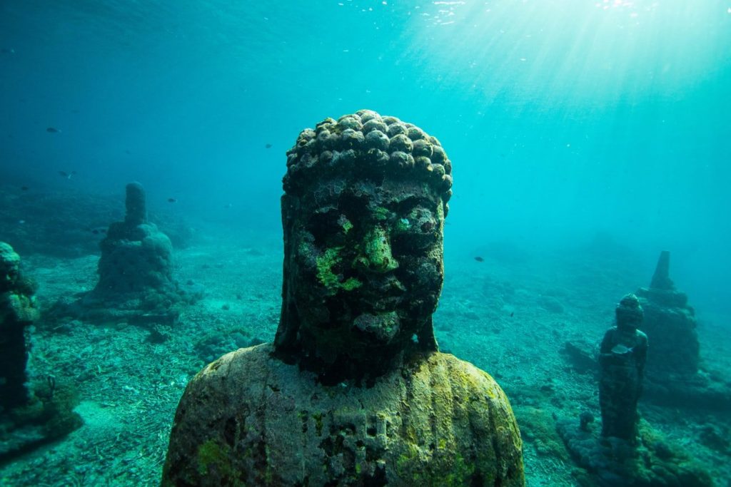
Malta
This first segment of Hancock’s programme examines Malta, an island in the Mediterranean north of the African coast, and Bimini, an island of the Bahamas.
I agree that the scale of structures which exist on Malta is amazing and difficult to explain. I agree that more work needs to be done offshore there. The flooding of the link between Malta-Sicily-Italy is important.
There is a famous length of submerged “cart-track” which crosses a bay on the coast of Malta near a town called Birzebbugia. These “cart tracks” have been known for decades and there was a major article on them in the Geographic Journal last year. I snorkeled on them in about 1985. There are two parallel tracks that can seen sloping down the bedrock into the sea.
Instead of filming these, Hancock chose to film a perfectly normal groove in the rock many miles away; a cave which looks a bit square; and a submerged rock arch. Several shots in the film showed dozens of caves along the coastal cliff, all of which are entirely natural.
Malta is composed of limestone. Since limestone bedding is often horizontal, roofs of limestone caves are often straight and squarish. Why was the underwater cave any different?
Martineau did an extensive survey of submarine caves in Malta in the 1960’s.
If Hancock wanted to prove that the things he saw were man-made – and I mean prove – then he, too, should have made an exhaustive survey of the region to determine whether similar features occur naturally. He should have shown that the one arch that he thought was man-made was so different from all the natural ones that his conclusion was inescapable. Yet there were no measurements, and there is no evidence.
Give Hancock a clue about a nearby submerged village – Atlit – or a Paleolithic cave with paintings 19,000 years old 40 metres deep in the sea – Cosquer – and he goes off in the opposite direction and photographs a natural piece of rock and says it is part of some lost civilisation.
The discussion about earlier pre-Megalithic occupation of Malta was interesting (without need for lost kingdoms). My own guess – and it is totally a guess – is that 30,000 to 40,000 years ago people were hunting and living in Italy, on Sicily and on the associated Malta promontory. But in that Palaeolithic time small numbers of people needed vast areas on which to hunt. When Malta was cut off as the sea level rose it could not support a separate population as a sustainable breeding group. The same happened to Kangaroo Island off south Australia. This resulted in a huge span of time passing before the island of Malta could be re-occupied by people who had developed boats, and who built the megalithic temples. The earlier Palaeolithic phase would now be very difficult to find, and much of it would be under the sea. That is worth researching.
The stuff about Malta being Atlantis is just for fun.
Bimini
The Bimini ‘road feature’ has been filmed dozens of times before, as Hancock gallantly said. Gifford and others dived on it in the 1970’s and drilled and sampled the rock and showed that it was all natural. The only new aspect presented by Hancock concerned a story about granite blocks. He suggested that granite blocks were precisely aligned on top of the “road feature” and were lifted off before 1930. This is pretty rich.
Since the “road feature” was not discovered until the 1960’s, how on earth could Hancock’s delightful informant know that the granite was on top of the “road”? The existence of wrecked cargoes of masonry in the area is well known, and Blashford Snell dived on them in the 1980’s. Granting that the stone was quarried from somewhere within five to ten miles of the “road feature” does not prove that there existed a multi-coursed structure. This is a classic case of the wildest wishful thinking. The dodgy logic of this argument is breathtaking.
There was a actually a complete contradiction between the presentation about Malta and that about the Bahamas. In Malta we were asked to believe that ancient peoples would naturally build on the highest hills, and in the case of the Bahamas we were asked to believe the opposite.
Many of the computer graphics showing the rising sea, ancient shorelines and melting ice caps were well done and illustrated the facts extremely well. Good educational stuff. But, the use of “morphing” graphics was brilliantly deceptive.
On several occasions a very irregular rocky feature with weeds and flickering colour gradually became smoother, straighter, more uniform, and more artificial, like a conjuring trick before your very eyes. I was impressed by the process, although it is common enough in commercial advertisements and movies like Terminator. The effect was extremely forceful in pressing the viewer to see what the producers wanted. There is nothing wrong with the use of these techniques, the effects are overt, but the cleverness of the technique does not make the assertion true. The rocks were natural.
Review of Part II
It was very refreshing to start with genuine underwater footage of real ruins. I felt at home, and could have done with many more pictures of the underwater city of Dvaraka.
Unfortunately, most of this second programme was spent walking about inland.
We saw visits to a wide range of villages, temples, inland archaeological sites, various experts and even a yoga school to discuss the general theory of the archaeological sequence in India. I cannot imagine that a single person enquiring over the course of a few months could produce a credible revision of the entire archaeological corpus of data on the sub-continent of India, yet that seemed to be Graham Hancock’s objective.
The dating of Dvaraka is published as 3700 years (S. R. Rao). Hancock disputes this, and suggests Dvaraka is only 1200 years old. By comparison with Bronze Age coastal cities in the Mediterranean, the earlier date would be perfectly acceptable. Hancock seeks to advantage his Flooded Kingdom theory by questioning the earlier date and thus make Dvaraka seem very recent so that subsequent footage of much less credible underwater “ruins” would seem to compare favourably with Dvaraka.
I was puzzled that a programme purporting to be about ruins under the sea only had a few minutes in total of undersea footage. I had expected at least 20-30 minutes of underwater pictures, with extensive presentation of acoustic side-scan images. Instead, we only got a quick flash of the same pictures which have appeared on the Graham Hancock web site.
Methodology
It is reasonable in scientific work to develop a series of stages of experiment, data, and deduction which can be demonstrably proven as true, and then to conclude the presentation with some suggestions as to the next stage of work which might be useful. These may be based on logical projections of the argument, or on hunches or speculation. This is accepted at the end of an argument, because it indicates logical possibilities that should be checked out for future research
For example, when I speculated on the basis of the connection between Malta-Sicily and Italy that Palaeolithic tribes had hunted on the continental shelf, and that this proposition could be checked, this was a reasonable proposition on the basis of the previous established evidence. [Ed. note – see section “Review of Part I” above.]
But this line of logic does not work in reverse.
You cannot make a legitimate chain of arguments which goes “A may have happened and it is possible that B happened and what if C happened and therefore I conclude definitely that there were Flooded Kingdoms in the Ice Age”. In the social sciences there are usually dozens of plausible alternative possibilities.
Thus, each time that Hancock says “A” may have happened he must also concede that multiple other things are equally likely to be the explanation. For instance, after three such steps for which a chain of five alternatives has been suggested three times, 125 different possible outcomes or explanations are possible.
Yet only one of these chains might – conservatively – be supported by and be consistent with the Flooded Kingdom proposition.
The normal scientific procedure when confronted with 125 possible explanations for events is to first weed out the non-starters, and reduce the field before spending time and money on expensive research. A quick check on the Flooded Kingdoms proposition would show masses of evidence against it from the hundred or more known stone-age sites on the continental shelf, and evidence of contemporaneous cultures on land and that would be the end of the argument. To waste any more time on the Flooded Kingdoms proposal would be a blunder.
Instead, after listing multiple chains of “possibly, what-if and could-it-be” Hancock concludes that his one and only proposal, the Flooded Kingdoms hypotheses, is strongly substantiated.
It is not.
Another technique used by Hancock is frequent references such as “I have now discovered…” or “Now I know that…” as if points presented were his original discoveries. In most cases the “discovery” has been known to students of archaeology and oceanography for decades, and could have been summarized in a few minutes, leaving time for some really original footage of underwater ruins, if they exist.
One general example of this is presentation of computer generated maps showing the seas. We returned again and again to different versions of this, and sometimes the same version more than once. The technique developed by Dr Milne is undoubtedly useful, and could have been used once or twice. However, any modern atlas, such as the Times Concise Atlas shows approximately the depth of the sea on the continental shelf. My atlas at home (not a research document) shows the depth contours at 25 metres, 50 metres, and 200metres with a change of blue tint at each contour, for every country with a sea coast. Anyone with such a common atlas can see immediately the light blue area out to the 200m contour, the limit of the continental shelf. If you know that the Ice Age sea level was at -25 metres about 8000 years ago, and -50 metres about 10,000 years ago, the two intermediate colours tell you where the coastline was at these two dates. That is not rocket science. You can do it at home.
My concern is that much of this presentation seemed designed to baffle and impress the viewer, to mystify rather than to explain matters which are fundamentally very simple, and fun. There are probably stone-age human occupation sites off every coast in the world, and any scuba diver could find artifacts with a bit of luck, and with the correct information of what to look for. It is not a mystery.
Mythology
Graham Hancock is correct in this assessment of the last Ice Age:
– The global sea level was about 150 metres lower during the peak of the last Ice Age, about 20,000 years ago.
– Human beings, and all the normal vegetation and fauna of the neighbouring land-mass, extended out onto the continental during the Ice Age period from roughly 100,000 years ago to 5,000 years ago.
– As the sea rose again vegetation was gradually killed off by salination and inundated and animals and people who had been on the continental shelf moved inland where they joined the people who had already been living there.
– Flood myths which occur all over the world are the “folk memory” of the experience of suffering 10,000 years of rising sea level.
The thesis that the late-glacial rise of sea level was the cause of widespread flood myths was presented in great detail in a book published by F.J. North in 1957 (see refs below). I read this a few years later, and expanded the logic in Chapter One of my book “Cities in the Sea”, published in 1970 in the USA, 1971 in UK, and a few years later in Japan. This model is widely accepted, and has been developed independently by several researchers.
This second programme criss-crossed between three general mythologies – the “Flood Myth”, the Myth of the “Golden Age”, and the Myth of “The Fall of Man”. Certainly these do interact on each other, as is evident from the Old Testament, and other religious texts. Life is, and always has been, a rather frustrating and puzzling experience. There are good times, but still, most of us also experience some pretty nasty things. When this happens we long to know why. Was life always so unjust? Did people always suffer? Do the gods really care nothing about us? Thus many belief systems produce ideas or concepts relating to a period when things were better in the past, or, in some religions, when they will be better after death. The change from that idyllic past to the reality of the present is portrayed either as simply loss of the perfect state – “Golden Age” – or a moral punishment for sin – “Fall of Man”.
The myths as referred to by Hancock are somewhat wrapped round each other, and imply that the Indians (and other peoples) believe in a wonderful period in the past when people had been richer and happier and that they also believe in Flood Myths. Both events are in the past! By Hancock’s logic, the cultures that existed at the time of the sea level rise were the rich and technically developed cultures of the Golden Age.
The confusion or merging of the myths is very convenient for the “Flooded Kingdoms” proposition but it does not work.
The Fall and the Golden Age have no reference to place and time. They are purely spiritual or psychological concepts, even though they are sometimes fitted into a theological chronology.
The Flood is very much time and site specific.
The Flood Myth becomes embedded in stone age culture during the period 20,000 to 5,000 years Before Present ( BP) because of the intensive way which pre-literate peoples relate to the land and nature in general.
If you live by hunting and finding wild plants and roots and insects which are good to eat, and rely on finding regular supplies of freshwater in the ground, you develop an encyclopaedic knowledge of the terrain. Aboriginal peoples in Australia, and probably other hunting cultures such as African Bushmen, memorise voluminous path or track narratives, describing every rock, shelter, shrub, and spring, shade, and danger along hundreds, if not thousands, of miles of track. These memorised records have to be handed down from generation to generation, along with all the additional data about seasons, migration of animals, geographical variation in climate, and so on.
One can see the impact that a continuously rising sea level would have on coastal pre-literate hunting or migratory cultures. Even if the vertical change within a few decades might seem small, the horizontal incursion was observable, and hunting tracks that were functional during one generation could be flooded and useless two or three generations later. Rising sea level became one of the things a young hunter had to know about, along with the danger of storms, dangerous animals, poisonous plants, and so on. It was obvious. The late Rhys Jones reported Australian tribal track records which had loops that extended offshore from the present coastline and tracked back again, because the “mental tape record” had not been altered. In some cases it was easier to keep the “tape” intact and add footnotes in daily life, rather than to alter the “master tape in the mind”.
When I was researching in 1982 on the Aborigine crossing routes from Timor to North Australia the Aborigine Council Leaders in Bathurst Island were perfectly aware that their ancestors had crossed the sea walking on the sea floor when the sea was lower. They had not learnt this from modern scientists. They saw us as the novice beginners studying an obvious fact, and they encouraged our research using divers.
By about 10,000 years BP we find Neolithic villages in many parts of Europe, Africa, and Asia. (See Mellart, the Neolithic of the Middle East) Several such villages have been found under the sea. (See Galili, Efstratiou, Flemming, and others). Towns such as Catal Huyuk in Turkey were founded in this period. The Neolithic people had settled down, started building villages and small towns, and began to practice agriculture and, on the coast, more advanced methods of fishing.
When the sea level rose over a Neolithic village the occupants were forced to abandon a significant investment in capital structures. That hurt. In practice, a rise of one metre per 100 years would force the occupants to abandon houses on the waterfront, and build on the landward side of the settlement, until, due to the topography of the site, the whole settlement might have to be deserted. This process seems to have occurred at Aghios Petros (Efstratiou, Flemming) and at Atlit (Galili).
All this time we are talking about pre-literate cultures. In particular it is inconceivable that they could have had a system of counting time which was fixed to an absolute reference point over thousands of years. By the time the sea level settled down at its present level 5000 years ago, the demonised and threatening rise of the sea was something which had occurred in the far off past. It had become a legend: “In the time of the gods”, “Before the great king who founded our city”, (eg.Gilgamesh), or whatever was the local myth system.
The cultural specification of the date of the Flood could only be fixed when a culture had advanced to the point of possessing a writing system and a dating system, and the technology for preservation of records. When this was occured, the regional or local Flood Myth became fixed at a defined time, and was not dragged forward by the oral transmission of the story from one generation to the next. This fixing of the Flood Myth happened at different times in different cultures, with the earliest ones we know of in the Epic of Gilgamesh, the story of Noah, and some Indian legends. The story in each case becomes embellished with details of the culture at the time it was written down and not when the sea was rising. This is also true of the Welsh legends recorded by F. J. North, which only trace back one or two thousand years to the date of being written down.
The important point to note is that this sequence leads to Flood Myths which were written down and known now as always being written by people who have invented writing (obviously) , and who are therefore already living in cities. They describe the Flood as if it inundated a culture like their own, with buildings and roads.
Additionally they compressed the timescale, because no one could have enumerated a timescale of thousands of years until considerably later (as, for example, Plato did).
All scientists and archaeologists who have studied this problem have concluded that the Flood Myth does refer to the cumulative memory of the post-glacial sea level rise, but that the reference to great cities and catastrophic floods is inadvertently attached from the culture and technology of the time when the stories are written down. They should be separate.
The mistake Graham Hancock makes in this programme is to move the Flood Myth and the big cities and the writing back together into the Paleolithic at 10-20,000 years ago.
Sonar
The programme got back in the water off southeast India, at Poompuhar. Fishermen had been losing nets snagged on underwater outcrops. Unfortunately the film crew could not dive on the outcrop that was suspected most surely of being archaeological, so they dived on another one. The underwater photography was quite genuine, and was not computer enhanced. Bedding planes in the rock were pointed to with a knife, and presumed to be the boundaries of man-made blocks.
Subsequently computer graphics were used to re-create the shape of the structure that Hancock thought had been discovered and which he said could be a ritual enclosure. This reviewer, and Dr Neil Kenyon, a scientist at SOC specialising for decades in acoustic surveying of sedimentary and sea bed geological structures, concluded that the outcrop was completely natural.
In the last few minutes the programme moved back to the subject of Cambay.
I had expected this site to be treated in detail, with lengthy viewing of many sections of the side-scan sonar record over many miles of ship-track, indicating the vast area of rectangular structures that constituted the city.
But this was not given to us. The same tiny images which have been on Graham Hancock’s web-site for many weeks were flashed onto the screen, discussed very briefly, and then removed. Of the “nine-miles” of presumed city only one or two images each a few hundred metres across have been shown to us.
Yet these scratchy side-scan images were suddenly morphed into a magnificent city with multi-storey buildings in a drama worthy of Toy Story or Monsters Inc.
Experts on acoustics, sidescan sonar, and sub-bottom profiling at the Southampton Oceanography Centre, UK, have examined the images on the official Graham Hancock website. Their opinions are not identical, but can be combined and summarised as follows:
Any resemblance of the images to a rectangular structure on the seabed is a coincidence. Sonar images are not black-and-white photographs. The non-expert viewer interprets them as a perspective snapshot of an area viewed from a particular point. In fact the side-scan image is built up line by line below a ship, which is always looking straight down and to each side along each line. Thus the apparent shape of “objects” in the image depends upon the ship’s speed, the lateral range of the sonar beam on each side, and the speed of the paper in the printer. Since none of those data can be deduced from the images displayed on the web site, the shapes shown on the screen of the side-scans are largely a coincidental illusion. No further information on the missing data was provided in the programme.
The “diamond” pattern with the proportions shown presents a strong illusion of being a rectangle with vertical relief, illuminated from the upper left. The human eye is strongly conditioned to make this deduction from our experience of photography and perspective drawings. Side-scan Plate No. 3 is labeled 97m x 24m, in a ratio of 4:1 (approx). But the picture is at best 2:1, and so the image should be compressed top-to-bottom by a factor of two (or, less probably, compressed left-to-right by much more). The most probable correction results in a pattern of lineation intersecting at 10-15 degrees. It is interesting that Hancock himself reports in the book Underworld (p.675) that neither the Indian National Institute of Oceanography, nor the Archaeological Survey believed that the findings were of human origin, and the NIO experts considered that the illusion in the side-scan images was synthesised by the acoustic process and had no significance. NIO is a world-class institution, and I would trust their judgement.
Side-scan systems either print strong echo = black, or strong echo= white. It is not clear which convention is being used. This again emphasises that the illusion is arbitrary, like those trick games: 6 cubes or 7? A duck or an old woman?
In Plate No. 3 there are regions of the picture at top left and bottom right which do not show the linear-intersecting pattern. In both cases there is a simple lineation from upper right to lower left, just striations. Because of the strong currents in the area these features are probably linear dune-like ribbons sculpted in sand or other loose sediments. These blend in the centre of the picture into the intersecting pattern. This transition is perfectly natural in geomorphological features, but is very odd in a human structure. The same transition is apparent in Plate 4, at the upper left.
There is no evidence in the sidescan image to confirm precisely the origin of the reported outcrops, My first impression , before I had even seen the pictures, was that the “underwater city 9 km long” would turn out to be natural fossil beach rock. Further scrutiny, combined with the so-called artifacts (see below) suggests that the hard ridges are outcrops of shale or mudstone. Beach rock is a natural cementation of beach sands rich in siliceous sands and carbonates which react with sunlight and salt water at the water’s edge on tropical beaches. The result is a strip of rock a few metres wide that can extend horizontally for many miles. If more sand is transported onto the beach successive layers of rock accumulate to seawards, absolutely flat and straight along the beach, but with a very slight tilt towards the sea, which was the original beach gradient. Such features can be many tens of metres wide, even a hundred metres or more.
The sub-bottom profiler images look much more complex than necessary. The exaggerated features at the bottom of the picture are simply the double echoes which result in a second version of the true echo at the top of the picture, but with twice the amplitude. These can be ignored. From the web site it is not possible to read the scales, either vertical or horizontal, but the features are probably a few metres high, and tens of metres across. This is in the range of the dimension one would expect from beach rock strips, and reasonable for one limb of an eroded anticlynal bedrock structure.
Since the position of the track of the sub-bottom profiler is not known in relation to the sidescan images, it is not possible to correlate them accurately. The discussion on the TV programme that the sub-bottom profiler showed “deep foundations” was absurd. Acoustic profiling images always show deep lines of greyish scattering within soft sediments, and a hard echo with pure white paper underneath from rocky surfaces. The contrast between the two looks like “deep foundations”. It always does.
Sea bottom samples
I was astonished by the extremely unconvincing nature of the so-called artifacts shown on the TV screen, and which I have viewed from images obtained via the web. My immediate impression was that these objects are mostly natural rolled pebbles, concretions, and other normal seabed phenomena. If I had found material like this on the sea floor I would not have expected the public to believe that they are artifacts.
Dr Neil Kenyon, a colleague at SOC who has published more than 100 papers on the use of sidescan sonar and sub-bottom profiling to analyse seabed sediments and geological outcrops. He has worked recently in the Arabian Sea and the Gulf of Hormuz and provides the following comments:
Although only based on the images seen on the TV programme, the materials dredged up from the Cambay site and presented as human artifacts all appear to be well-known natural geological features and fossils, familiar to any sedimentary geologist who has worked in the Indian Ocean, Arabian Sea, or Arabian Gulf region. The flat stones which looked so smooth are natural fragments of shale or mudstone, probably from a natural outcrop known to the Geological Survey of India. Most continental shelves have been surveyed acoustically for military and offshore petroleum purposes. The outcrop would probably be plotted on available marine geological maps. The flat stone fragments have been rolled in the strong currents on the seabed, and blasted with suspended sand particles, which has made them smooth, like beach pebbles.
Some of them had been perforated by boring molluscs, seashells which eat calcareous rock, and this accounted for the holes in them. The nodular and cylindrical objects are natural concretions and fossils. The object that looked as if it has been turned on a lathe is just a nodule that has been rolled on the sea bed by the current.
The flat grey object which GH said had got writing on it is a well known fossil from this area, and is popularly known to geologists as a “hieroglyph fossil” because of the patterns on its surface. It is probably several million years old. This fossil is typical of layers of shale and mudstone of this age. Although I had only a glance at them the trace fossils could be Palaeodictyon or Helminthoida.
Many objects left on the sea floor in these climatic conditions become concreted rapidly with calcareous deposits. The so-called human jawbone is probably an object that has been coated in natural calcareous limestone precipitated on the seabed. Inside the hard white coating there could be a bent piece of wood, or a fish-bone. These possibilities should be checked.
All the materials displayed on the film were the sort of natural objects which a sedimentary geologist would expect to find anywhere in the tropics on the seabed, dating to millions of years old, but moved, altered, and concreted by modern currents, boring organisms, and natural chemical processes of seawater.
In short, there is no evidence that these objects are man-made. Any piece of debris or old tree root stuck on the seabed could have, by chance, provided the convenient carbon 14 date.
Review of Part III
The third installment of Flooded Kingdoms opens with a voice-over describing Graham Hancock’s search through many lands for the secret of lost kingdoms beneath the sea. The implication is that no-one else has ever had the idea of performing prehistoric archaeology on the continental shelf. Most archaeologists accept the overwhelming evidence that the people who lived on the continental shelf during the last ice age had exactly the same level of cultural development as the more commonly studied peoples living at that time on the present dry land masses.
Yonaguni
Graham Hancock said:
Nobody can tell us who lived on the continental shelf 10,000 years ago.
This is not true.
We go on a dive on Yonaguni, a small island belonging now to Japan, but actually 1000 kilometres from the mainland of Japan and only 100 kilometres from Taiwan. Yonaguni was always a remote island, even during times of lowest sea level. When the Hancock’s film company visited me in June 2000 I advised them to visit the thoroughly excavated Jomon culture site off the Tokonami River at a depth of 25 metres which is proven to be 9000 years old and which has been published by Kenzo Hayashida. It is off the coast of Kyushu, part of the main islands of Japan, facing the Tsushima Channel. Tokonami has provided extensive finds of pottery, bones, flint tools, and organic materials. I also recommended consulting Wataru Ishihara who lists about 50 palaeolithic coastal sites in Japan. Instead, they chose to film Yonaguni, which is widely presumed to be a natural geological feature.
A sequence of dives with Wolf Wichman, a German geologist, are well done, and there is a discussion with Hancock asserting that the landforms must have been cut by humans, while Wichman asserts that they are natural. Japanese archaeologist Professor Kimura and visiting Indian archaeologist Dr Sundaresh considered it to be man-made.
There are real ambiguities in separating man-made and naturally occurring rock features. Neither geologists nor archaeologists have a monopoly of wisdom on this. However, the geologists have an advantage if they can say:
I have seen exactly the same kind of formation many times before in all sorts of totally natural conditions
The archaeologists then have to prove that in this particular case the formation is not natural (like all the others) but is man-made. In the absence of pottery, organics, soil, bones, or any other artefacts this is very difficult. That is the present status of Yonaguni. Geologists think it is natural.
Proposals that odd rock features must be man-made because they are so improbable are seldom valid. People who make this kind of statement should look in detail through any good text book on geology or geomorphology to see the weird landforms, tors, yardangs, stacks, natural arches, standing stones, ledges, pillars, drying lake mud, cooled columns of lava, concretions, glacial erratics, geodes, pedogenic concretions, igneous intrusions, dykes, scour pools, drip-stones and the like that occur in nature. At Pammukkale in Turkey you can see a mountainside covered in a cascade of pure white projecting rock basins shaped like lotus leaves, each the size of a Hollywood swimming pool, dripping crystal clear water. This is not the result of a mad king’s obsession with cleanliness, it is natural. Nearby at Urgup there is a valley full of stone mushrooms tens of metres high. They are natural, though people do often hollow them out to live in them. Nature can be absolutely weird.
A major weakness of the archaeological case for a man-made origin of the Yonaguni feature is its uselessness. Hancock shifted the case backwards and forwards between a ceremonial site for rock worship, a pool, various passages and terraces, and finally a harbour. It looked totally useless as a harbour to me, and I have surveyed hundreds of ancient harbours. Since the “feature” mapped by Hancock and others seems to extend down to a depth of only 30 metres (90 feet) the whole feature would have been more than 50-100 metres above sea level at its base and a considerable distance from the seashore 10,000 years ago. The supposed man-made object would have been an irregular stepped outcrop on top of a hill set way back from the sea. How could it be a harbour? His different alleged uses also all depended upon different relations to sea level. Also, there was no mention of other Jomon sites on the island of Yonaguni itself, if they exist. Since the island was always separated from both Taiwan and the mainland of Japan, even at times of lowest sea level, who was trying to live in this isolated spot or sail boats to it 10,000 years ago?
There was much discussion about the missing debris which might have fallen from the exposed flat ledges. This argument seemed to ignore the fact that the ledges may have been exposed in their present form, more or less, for many hundreds of thousands, or even millions, of years. The sandstone would then have broken up through frost and rain weathering, as suggested by Wolf Wichman, and the rock debris or scree itself would have had many tens of thousands of years to be broken into small pieces which were washed away by the rising sea.
The programme next devoted some time to discussion of Shinto religious beliefs and associated myths and legends. I cannot comment on the theories put forward in this section except to say that they seemed very speculative.
Jomon Culture
Hancock then said that very little is known about people who were around at the end of the Ice Age. Were they primitive hunters, or were they an advanced civilisation? The evidence of other speakers in the programme showed that a great deal is known about the Jomon culture although, as Charles Kealey said, one is always finding new data and some surprises. There followed a somewhat philosophical discussion about just what constitutes civilisation, and what can be considered to be primitive. This seemed to hark back to Hancock’s allegation that it is difficult to explain what early humans were doing between the evolution of Homo Sapiens about 100,000 years ago and the development of cities and writing at the conventionally dated periods of around 8000-5000 years ago. The explaination is not a difficult one.
These stages of development of human skills and arts are well substantiated as conventional archaeological sequences. Sophisticated stone tools, the control of fire, aerodynamically designed wooden javelins, and other obvious signs of intelligence are found well before 100,000 years. Home Sapiens developed the ability to cross water channels on rafts or boats, make a wide range of fine stone tools, paintings and rock art, domesticate some animals, practice religious burial and create cultural carvings, woven baskets and musical instruments during the period 50,000 to 10,000 years ago. Around 10,000 years ago the standard sequence suggests the development of agriculture with a full suite of domesticated animals, pottery, constructed houses, and soon thereafter villages and towns. This seems to me to be pretty clever, pretty fast. What more does Graham Hancock want? Palaeolithic peoples were not stupid, but rather were apparently quite sophisticated and cultured although around 10,000 ago they did not yet have big cities or writing. That took a little longer.
In order to prove the mathematical sophistication of the supposed missing kingdom, or the component of it which might be Jomon, Hancock then visited a reconstructed monument which included a reconstructed framework consisting of six large brand-new vertical timbers. We were told that at midsummer’s day the end of the shadow of one timber fell exactly on the midpoint between two other timbers, and this proved that the originators were sophisticated astronomers. The flaws in this are obvious. Firstly, how does anyone know exactly how long the timbers were originally? They were completely new. If the posts had been driven ten centimetres further into the ground or been five centimetres longer or shorter the shadows would have fallen somewhere else. On almost any day of the year at any time, one shadow or another would have fallen exactly onto the base of another timber, half way up a timber, two thirds of the way between the timbers, onto the mid-point of a square between four timbers, and so on. This proves nothing.
Hancock claimed that a line of important structures were situated exactly on the Tropic of Cancer. Yet, quite apart from the fact that the Yonaguni feature is not man-made, it is also noticeable that a great many important archaeological sites are NOT on the Tropic of Cancer. It is pure chance that some are, if they are. How do we know that there are more or less archaeological features at 10 degrees North, 20 degrees, 27 degrees, or 54 degrees? Has Hancock counted them all?
The discussion of stone circles made out of small stones was quite interesting. Similar man-made features are found in Australia. The significance and age of these very simple structures could be examined further, and I suspect that much work on this has been done in Australia.
Kerama
The diving team then visited Kerama Island, which would have been joined to Okinawa at glacial low sea level, but the combined island would still have been hundreds of
kilometres from both the Asian mainland and from Japan. A strange circular rock feature was investigated, and this time Wolf Wichman admitted that it was difficult to explain. Wichman said the rock was coralline limestone, and was sceptical of human origin. From my perspective it looked as if it could have been shaped, at least in part, by water scour driving pebbles or boulders round the central block. Although stone circles of various types have been found in connection with several cultures, the circular stone feature at Kerama did not resemble any of those previously shown on the programme.
Hancock concluded the third programme with a final verbal review of the ‘big sites’ – Malta, Cambay, and Yonaguni – and the speculation that maybe civilisation had been given a second chance. That we had once been civilised before, in the flooded kingdoms, wiped out by the rising sea, and then started again. However beautiful and mystical this story may be, the facts do not add up.
Archaeologists working all round the world have already found over 100 prehistoric sites on the continental shelves, and these fit into the usual sequence of ‘Palaeolithic to Neolithic’. We want to find many more sites, of course, and to find out about the maritime skills of the people who lived in them. But it is unbelievable that between these Palaeolithic or Neolithic settlements on the continental shelves there was an alternative branch of the human race, one that was technically sophisticated and living in big cities. These presumed cities would have been trapped between the more primitive sites on both sides and, for some reason, unable to go above the 150 metre contour to landwards, as they have left no traces for us to find on the present dry land. None of the 100 prehistoric sites recorded by archaeologists has ever been alleged to be natural geological features, while all of Hancock’s presumed flooded kingdom sites are alleged by many critics to be geological.
Conclusion
I found Graham Hancock’s Underworld to be clever but ultimately boring and unconvincing. It may, of course, convince those who haven’t studied the previous research. The anchorman and the film company are good at persuasion – that is their job.
But that does not mean the premise of the programme is true. The balance of judgment is firmly against any flooded kingdoms ever having existed.
Nic Flemming
Senior Scientist
Southampton Oceongraphy Centre
References
Annexe 1.
The first is a short list of books and articles which should be available to any good library, or a university library. There are also fairly frequent articles on this theme in Scientific American, Science et Vie, Nature, Science, and other leading scientific and archaeological journals.
Allen, J., Golson, J., and Jones R. 1977. Sunda and Sahul. Prehistoric studies in Southeast Asia, Melanesia and Australia. Academic Press. London. 647 pages.
Blondel, P., and Murton, B.J., 1997. Handbook of seafloor sonar imagery. John Wiley and Sons. 314 pages.
Clottes, J., and Courtin, J., 1994. The Cave beneath the sea. Harry N. Abrams. 200 pages.
Flemming, N.C., 1971. Cities in the Sea. Doubleday and New English Library.
Klein, R.G. 1999. The Human Career. University of Chicago Press. 807 pages.
Masters, P.M., and Flemming, N.C., (Eds.) 1983. Quaternary Coastlines and Marine Archaeology. Academic Press. London and New York. 641 pages.
North, F.J., 1957. Sunken Cities. Cardiff University Press. 256 pages.
Pederson, L.D., Fischer, A., and Aaby, B., The Danish Storaebaelt since the Ice Age: Man, Sea and Forest. Storebaelt Publications. 1997
Ruddiman, W.F., 2001. Earth climate past and future. W.H, Freeman. 465 pages.
Siegert, M.J., 2001. Ice sheets and late Quaternary environmental change. John Wiley and Sons. 231 pages.
Annexe 2
The second list of references provides most of the sources of information used in these reviews. The purpose of this list is to show that the matters raised by Hancock have been frequently studied by professional research workers from many fields. The repeated statements by Graham Hancock in all three programmes that no-one has ever studied the problem of post glacial inundation of human settlements on the continental shelf is wrong. This assertion is an insult to many excellent archaeologists and geologists in many countries. References not found in this list are included in the extended bibliography in Annexe 3.
Bailey, G.N., 1983. Problems of site formation and the interpretation of spatial and temporal discontinuities in the distribution of coastal middens. p.529-558 in : Masters, P.M. and Flemming, N.C., (Eds.). q.v.
Bell, M.M., 1980. Investigation of submerged beachrock deposits off Bimini, Bahamas. National Geographic Society Research Reports. v. 12. p.21-30.
Birdsell, J.B., 1953. Some environmental and cultural factors influencing the structuring of Australian Aborigine populations. The American Naturalist. v.87. p.171-207.
Birdsell, J.B., 1977. Recalibration of a paradigm for the first peopling of Greater Australia. In Allen J. , Golson, and Jones, (Eds.) (q.v.)
Blanc, A.C. 1937. Low levels of the Mediterranean Sea during the Pleistocene glaciation. Quarterly Journal of the Geological Society. 93. p.621-651.
Blanc, A.C., 1940. Industrie musteriane e paleolitiche superiori nelle dune fossili e nelle grotte litoranee del Capo Palinuro. Rendiconti della R. Accademia d’Italia. 10. Ser. 7. v.1. Roma.
Blanc, A.C., 1942. Variazioni climatiche ed oscillazioni della linea di riva nel Mediterraneo centrale durante l’era glaciale. Sonderdruck aus Geologie der Meere und Binnengewässer. Bd.5. Heft 2. p.137-219.
Blashford-Snell, J.N. 1981. The Bimini Reconnaissance Report. The Institute of Underwater Archaeology. Loose reprint. 4 pp.
Bonifay, E., 1973. Données géologiques sur la transgression versilienne le long des côtes françaises de la Méditerranée. Le Quaternaire: Géo-dynamique stratigraphie et environnement. Travaux français récents. p.137-42. Ninth International Conference of INQUA.
Bonifay, E., Courtin, J., and Thommeret, J., 1971. Datation des derniers Stades de la transgression versilienne dans la région de Marseille. Comptes-rendus de l’Académie des Sciences v. 273. p.2042.
Emery, K.O. 1966. Early Man may have roamed the Atlantic Shelf. Oceanus. vol. 12. no. 2. p.3-5.
Emery, K.O. and Edwards, R.L., 1964, Archaeological potential of the Atlantic continental shelf. American Antiquity. v.31.no.5 .p.733-737.
Fischer, A. 1995. Man and the sea in the mesolithic. Oxbow Monographs number 53. Oxbow Books. Oxford.
Gifford, J.A., and Ball, M.M., 1980. Investigation of submerged beachrock deposits off Bimini, Bahamas. National Geographic Society Research Reports, v.12. p.21-38.
Gifford, J.A., 1983. Core sampling of a holocene marine sedimentary sequence and underlying Neolithic cultural material off Franchthi Cave, Greece. p.269-282 in: Masters and Flemming, 1983a q.v.
Godwin N., 1941. Pollen-analysis and quaternary geology. Proceedings of the Geologists Association, v.52, p.328-361.
Harrison, W., 1971. Atlantis undiscovered – Bimini, Bahamas. Nature, v.230, p.287-289.
Hayashida, Kenzo, 1993. The archaeological materials from the Takashima Seabed, Tokonami harbour. Educational Committee of Takashima Town. Research report. 123 pp.
Hopkins, D.M. 1967. The Bering Land Bridge. Stanford University Press. Stanford, California. 495 pp.
Hughes, K.J., 1999. Persistent features from a palaeo-landscape: the ancient tracks of the Maltese Islands. The Geographical Journal. v.165. p.62-78.
Jones, R. 1977. Man as an element of a continental fauna: the case of the sundering of the Bassian Bridge. p.317-386, in: Allen, J., et al. (Eds.) q.v.
McKusick, M., and Shinn, E.A., 1980. Bahamian Atlantis reconsidered. Nature. v.287. p. 11- 12.
Martineau, M.P., 1966. Marine terraces in Malta. P .68-71. Symposium of the Underwater Association 1965. Lythgoe, J.N., and Woods, J.D. (Eds.) 71 pp. Underwater Association, UK.
Marshall, N.F., and Moriarty, J.R., 1964. Principles of underwater archaeology. Pacific Discovery. v.17. p.18-25.
Masters, P.M., and Flemming, N.C., (Eds). 1983. Quaternary Coastlines and Marine Archaeology. Academic Press, London and New York. 641pp.
Momber, G. (2001), Six fathoms down off Bouldnor Cliff: a Mesolithic site. p .65-69 in: A Decade of Diving, Delving and Disseminating. Hampshire and Wight Trust for Maritime Archaeology. 1991-2001. Sparks, B. Momber, G. and Sachell, J. Southampton Oceanography Centre. 80 pp.
Moriarty, J.R., 1963. The use of oceanography in the solution of problems in a. submarine archaeological site. Papers in marine geology. F.P. Shepard Commemorative Volume. p.511-522. MacMillan, New York.
Moriarty. J.R., Peyton, G., and Field, P., 1961. Prehistory sites in the San Diego coastal area. Science of Man, v.1, no.4. pp.116-119.
Murphy, L., 1978. 8 SLO 19: Specialised methodological, technological and physiological approaches to deep water excavation of a prehistoric site at Warm Mineral Springs, Florida. p.123-128 in: Barto-Arnold, J., (Ed.) Beneath the Waters of Time, 9th Conference of Underwater Archaeology, Texas Antiquities Committee, No.6.
Shepard, F.P., 1964. Sea level changes in the past 6000 years: possible archaeological significance. Science. v. 143, no. 3606. pp.574-576.
Skaarup, J., 1983. Submarine stenalderbopladser i Det sydfynske øhav. Af. Jørgen Skaarup. Findes i. (Submarine stone- age settlement sites in the South Funn archipelago). Antikvariske studier. v.6. p.137- 161, Antikvariske Studier, Bd. 6, S.137-61, ill.
Steers, J.A., 1946, The Coastline of England and Wales. Cambridge University Press. Cambridge. 644 pages.
Uchupi, E., 1964. Unusual hauls from the Georges Bank. Oceanus.v.10.no.4. pp.20-22. Woods Hole (retrieval of mammoth bones and teeth).
Werz, B.E.J.S., and Flemming, N.C., 2001. Discovery of the world’s oldest underwater finds in Table Bay demonstrates preservation of hominid artefacts on the continental shelf. South African Journal of Science. v. 97. May/June p.183-185
Annexe 3
The third list of references provides an extensive bibliography on the subject, covering climatology, Quaternary geology, tectonics, archaeology, and sedimentology of the continental shelf. I hope that this reading list will help archaeologists all over the world to pursue their tasks offshore more effectively, with the added knowledge of what is being done elsewhere.
AKEROYD, A.V., 1972. Archaeological and historical evidence for subsidence in southern Britain. Philosophical Transactions of the Royal Society, London, A. v.272, p.151-169.
ALLEN, J., GOLSON, J., AND JONES, R., 1977, Sunda and Sahul, Prehistoric studies in Southeast Asia, Melanesia and Australia. London, Academic Press, 647 pp.
AMBRASEYS, N.N., 1971. The value of historical records of earthquakes. Nature, v.232, p.375-379.
ANDERSEN, A.S.H. 1980. Tybrind Vig, a preliminary report on a submerged Ertebolle settlement on the Little Belt. Antikvariske Studier 4, 7-22.
BARWIS, J.H. & TANKARD, A.J. (1983). Pleistocene shoreline deposition and sea-level history at Swartklip, South Africa. J. Sed. Pet. 53, 1281-1294.
BEECHEY, F.W., 1827. Proceedings of the expedition to explore the north coast of Africa. John Murray, London. 572pp.
BELL, M., 1991. The Severn Estuary Levels Research Committee, Annual Report, 1990, 23pp.
BIRDSELL, J.B., 1977. The recalibration of a paradigm for the first peopling of Greater Australia. In: Allen J., Golson,J., and Jones, R., (eds.), Sunda and Sahul, Prehistoric Studies in Southeast Asia, Melanesia and Australia. Academic Press, London, pp. 113-167.
BLACKMAN, D.J., 1973. Evidence of sea level change in ancient harbours and coastal installations. Butterworth Press, Colston Symposium Papers, No. 23, p.114-137.
BLACKMAN, D.J., 1982. Ancient harbours in the Mediterranean. Part 1 and Part 2. International Journal of Nautical Archaeology, v.11, p.79-104 and p.185-211.
Blanc, A.C., 1940. Industrie musteriane e paleolitiche superiori nelle dune fossili e nelle grotte litoranee del Capo Palinuro. Rendiconti della R. Accademia d’Italia. 10. Ser. 7. v.1. Roma.
BLUE, L. AND FLEMMING, N.C.,(eds), 1994. UNEP-MAP catalogue of Mediterranean coastal archaeological sites, 2 vols, plus maps, photographs and disk database. (Unpublished, held by UNEP-MAP, Athens)
BOWDLER, S. 1977. The coastal colonisation of Australia. in: Allen, Golson, and Jones (q.v). p.205-246.
CHAPPELL, J., AND THOM, B., 1977. Sea levels and coasts, in: Allen, J., Golson, J., and Jones, R., (Eds). Sunda and Sahul, Academic Press, London, 647pp.
CLARK, G., 1969. World Prehistory. Cambridge University Press, 331 pp.
CLARK, J.A. AND LINGLE, C.S., 1978. Predicted relative sea-level changes (18,000 BP to present) caused by late glacial retreat of the Antarctic Ice Sheet. Quarternary Research v.9, p.265-287.
CLAUSEN, C.J., COHEN, A.D., EMILIANI, C., HOLMAN, J.A., AND STRIPP, J.J., 1979. Little Salt Spring, Florida: a unique underwater site. Science, v.203. p.609-614.
CLIMAP Project Members (1984). The last interglacial ocean. Quat. Res. 21, 123-224.
CLOTTES, J. and COURTIN, J., 1992. La Grotte Cosquer un an après. Archeologia, v.283, p.14-19.
CLOTTES, J., BELTRAN, A., COURTIN, J., AND COSQUER, H., 1992. The Cosquer cave on Cape Morgiou, Marseilles. Antiquity, v.66, p.583-598.
COCKRELL, W.A., 1980. Drowned sites in North America. p.138-145 in: Archaeology Underwater, Muckelroy, K. (Ed). McGraw Hill, New York and London, 192 pp.
COCKRELL, W.A., 1986. The Warm Mineral Springs archaeological research project: current research and technological applications. In: Diving for Science..86, Charles T. Mitchell (Ed.), American Academy of Underwater Sciences, p.63-68.
COCKRELL, W.A., AND MURPHY, L., 1978. 8 SL 17: Methodological approaches to a dual component marine site on the Florida Atlantic coast. p.175-182 in: Beneath the Waters of Time, Barto-Arnold, J., (Ed.), 9th Conference on Underwater Archaeology, Texas Antiquities Committee, Publication No. 6.
DEACON, H.J., GELEIJNSE, V.B., THACKERAY, A.I., THACKERAY, J.F., TASENIUS, M.L. 1986. Late Pleistocene cave deposits in the Southern Cape. Current research at Klasies River. Paleoecology of Africa, v. 17, p.31-38.d
DINGLE, R.V. (1971). Tertiary sedimentary history of the continental shelf off the southern Cape Province, South Africa. Geol. Soc. S. Afr. Trans. 74. 173-186.
DIOLÉ, P., 1952. Promenades d’Archéologie sous-marine. Paris, Albin Michel. (Translated as 4000 years under the Sea, London, Sidgwick and Jackson, 320 pp.
DUNBAR, J.S., 1988. Archaeological sites in the drowned Tertiary karst region of the eastern Gulf. The Florida Anthropologist, v.41, p.177-181
DUNBAR, J.S., WEBB, S.D., AND FAUGHT, M., 1992. Inundated prehistoric sites in Apalachee Bay, Florida, and the search for the Clovis shoreline. In: Johnson, L.L., and Stright, M. (Eds) (q.v.) p.117-146.
DVORAK, J.J., AND MASTROLORENZO, G., 1990. History of vertical movement in Pozzuoli Bay, southern Italy: the result of regional extension related to evolution of the Tyrrhenian Sea and of local volcanic activity. Geol. Soc. Am., Spec. Pap. 263, 47 pp.
EMERY, K.O., AND EDWARDS, R.L., 1966. Archaeological potential of the Atlantic continental shelf. American Antiquity 31, p.733-737.
EMERY, K.O., AUBREY, D.G., AND GOLDSMITH, V., 1988. Coastal neo-tectonics of the Mediterranean from tide-gauge records. Tectonophysics, v. 120, p.239-255.
EROL, O., and PIRAZZOLI, P.A., 1992. Seleucia Pieria: an ancient harbour submitted to two successive uplifts. International Journal of Nautical Archaeology, v.21., p.317-327.
FAIRBRIDGE, R.W., 1961. Eustatic changes in sea level. Physics and chemistry of the earth, v.4, Pergamon, London, p.99-185.
FISCHER, A., 1993. Stenalderbopladser i Smalandsfarvandet (Stone Age settlements in the Smaland Bight: a theory tested by diving). Miljoministeriet, Skov- og Naturstyrelsen. Kobenhavn. 131 pp.
FLEMMING, B.W. (1976). Rocky Bank, evidence for a relict wave-cut platform. Ann. S. Afr. Mus. 71, 33-48.
FLEMMING, N.C., 1962. Sunken cities and forgotten wrecks. in: Oceans, G.F. Deacon (Ed.), Paul Hamlyn, London, 297 pp. p.96-106.
FLEMMING, N.C., 1968. Holocene earth movements and eustatic sea level change in the Peloponnese. Nature, London, v.217, pp. 1031-1032.
FLEMMING, N.C., 1969. Archaeological evidence for eustatic change in sea level and earth movements in the Western Mediterranean in the last 2000 years. Geological Society of America Bulletin, Special Paper 109, 125 pp.
FLEMMING, N.C., 1971. Cities in the Sea. Doubleday, New York, 222 pp.
FLEMMING, N.C., 1973. Archaeological evidence for eustatic and tectonic components of relative sea level change in the South Aegean. Butterworth Press, Colston Symposium Papers, No.23, p. 1-66.
FLEMMING, N.C., 1973. Science Diving International (editor). 282 pp. BSAC, London.
FLEMMING, N.C., 1978. Holocene eustatic changes and coastal tectonics in the north-east Mediterranean: implications for models of crustal consumption. Philosophical Transactions of the Royal Society, London, A, v.289. p.405-458.
FLEMMING, N.C., 1981. Preservation and Rescue: Challenges and Controversies in the protection of archaeological resources. Journal of Field Archaeology, v.8. p.505.
FLEMMING, N.C., 1983 Preliminary geomorphological survey of an early Neolithic submerged site in the Sporadhes, N. Aegean. p.233-268 in: Masters and Flemming, 1983a q.v.
FLEMMING, N.C., 1983 Survival of submerged lithic and Bronze Age artefact sites: a review of case histories. p.135-174 in: Masters and Flemming, 1983a q.v.
FLEMMING, N.C., 1985. Ice Ages and human occupation of the Continental Shelf. Oceanus, v.28. no.1, p.18-26.
FLEMMING, N.C., 1986. A survey of the late Quaternary landscape of the Cootamundra Shoals, North Australia: a preliminary report. p. 149-180 in: Flemming N. C., Marchetti F., and Stefanon A., (Eds). Proceedings of the 7th International Diving Science Symposium of CMAS 1983, Padova, Italy, 377 pp.
FLEMMING, N.C., 1988. Predictions of relative coastal sea-level change in the Mediterranean based on archaeological, historical and tide-gauge data. UNEP Joint Meeting on the Implications of Climatic Change, Split, Yugoslavia. (UNEP(OCA)/WG.2/13. 33pp.
FLEMMING, N.C., 1993. Predictions of Relative Coastal Sea-Level Change in the Mediterranean Based on Archaeological, Historical and Tide-Gauge Data. Chapter 8, p. 247-281, in: Jeftic, L., Milliman, J.D., and Sestini, G., (eds.) Climatic Change and the Mediterranean, Edward Arnold, London, 673 pp.
FLEMMING, N.C., 1996. Sea level, neotectonics, and changes in coastal settlements: threat and response. p. 23- 52, in: E. E. Rice (Ed) , The Sea and History, Sutton Publishing, Stroud, pp.165.
FLEMMING, N.C., 1998. Archaeological evidence for vertical movement on the continental shelf during the Palaeolithic, Neolithic and Bronze Age periods. In: Stewart, I.S. and Vita-Finzi, C. (eds.) Coastal tectonics. Geological Society Special Publication 146, London, 129-146.
FLEMMING, N.C., AND KAZIANIS, D., 1987. Preliminary report on the Otranto Straits project. Report submitted to the Department of Antiquities, Underwater Archaeology Section, Greece.
FLEMMING, N.C., AND WEBB, C.O., 1986. Tectonic and eustatic coastal changes during the last 10,000 years derived from archaeological data. Zeitschrift für Geomorphologie, N.F., Supplement Band 62. p.1-29.
FLEMMING, N.C., and WOODWORTH, P.L., 1988. Monthly mean sea levels in Greece 1969-83 compared to relative vertical land movements measured over different timescales. Tectonophysics, v. 148, p. 59-72.
FLEMMING, N.C., RABAN, A., and GOETSCHEL, C., 1978. Tectonic and eustatic changes on the Mediterranean Coast of Israel in the last 9000 years. In: Beneath the Waters of Time, Barto-Arnold, J., (Ed.), 9th Conference on Underwater Archaeology, Texas Antiquities Committee, Publication No. 6.
FROST, H., 1963. Under the Mediterranean. Routledge and Kegan Paul, 278 pp.
FROST, H., 1972. Ancient harbours and anchorages in the eastern Mediterranean. p.95-114 in: Underwater Archaeology, a Nascent Discipline. Published by the United Nations (UNESCO), Paris.
GAGLIANO, S.M., PEARSON, C.E., WEINSTEIN, R.A., WISEMAN, D.E., and MCCLENDON, C.M., 1982. Sedimentary studies of prehistoric archaeological sites. Prepared for US Department of Interior National Park Service by Coastal Environment Inc., Baton Rouge, Louisiana, 120pp.
GALILI, E., 1987. A late Pre-Pottery Neolithic B site on the sea floor at Atlit. Mitkufat Haeven v.20, p.50-71.
GARRISON, E.G., 1992. Recent archaeogeophysical studies of the paleoshorelines of the Gulf of Mexico. In: Johnson, L.L., and Stright ,M. (Eds), (q.v.) p.103-116.
GEDDES, D.S., GUILAINE, J., and MONACO, A., 1983. Early Neolithic occupation on the submerged continental plateau of Roussillon, France. p.175-188 in: Masters and Flemming, 1983a q.v.
GIFFORD, J.A., 1983. Core sampling of a holocene marine sedimentary sequence and underlying Neolithic cultural material off Franchthi Cave, Greece. p.269-282 in: Masters and Flemming, 1983a q.v.
GIFFORD, J.A., REDKNAP, M. AND FLEMMING, N.C., 1985. The UNESCO international survey of underwater cultural heritage. World Archaeology, v.16, p.373-376.
GNIRS, A. 1908. Beobachtungen über den Fortschritt einer säkularen Niveau-schwankung des Meeres während der letzten zwei Jahrtausende. Mitteilungen der K.K. v.51. p.1-56.
GODWIN, N., 1941. Pollen-analysis and quaternary geology. Proceedings of the Geologists Association, v.52, p.328-361.
GORNITZ, V., LEBEDEFF, S., AND HANSEN, J., 1982. Global sea level trend in the past century. Science, v.215, p.1611-1614.
GÜNTHER, R.T., 1903. The submerged Greek and Roman foreshore near Naples. Archaeologia. v.58.
HAMILTON, D.L., 1984. Preliminary report on the archaeological investigations of the submerged remains of Port Royal, Jamaica, 1981-82. International Journal of Nautical Archaeology. v.13.1, p.11-25.
HAMILTON, W., 1776-79. I Campi Phlegraei. Peter Fabris. Naples. 90pp.+ 54 plates.
HARDING, A., CADOGAN, G., and HOWELL, R., 1969. Pavlopetri, an underwater Bronze Age town in Laconia. Annual of the British School at Athens, v.64. p.113-142.
HAYASHIDA, K., 1993. The archaeological materials from the Takashima seabed (Part II). Takashima Town cultural property research report. Educational Committee of Takashima Town, Nagasaki Prefecture. pp. 124.
HENDEY, Q.B. & COOKE, H.B.S. (1985). Kolpochoerus paiceae (Mammalia, Suidae) from Skurwerug, near Saldanha, South Africa, and its palaeoenvironmental implications. Ann. S. Afr. Mus. 97, 9-56.
HENDEY, Q.B. & VOLMAN, T.P. (1986). Last interglacial sea levels and coastal caves in the Cape Province, South Africa. Quat. Res. 25, 189-198.
HOFFECKER, J.F., POWERS, W.R., and GOEBEL, T., 1993. The colonization of Beringia and the peopling of the New World. Science, v. 259, p. 46-53.
ISHIHARA, W., 1982. Research of the ruins at the bottom of the sea and underwater archaeology in Japan. Surugadai-Shigaku, No,57. Separate volume. December 1982.
ISHIHARA, W. 1989. Distribution of seabed archaeological remains in Japan, and future problems. Proceedings of the Congress of the Confédération Mondiale des Activités Subaquatiques in Nagoya, vol. 3, p.33-38.
JAMESON, M.H., 1969. Excavations at Porto Cheli and Vicinity, Preliminary Report I: Halieis. 1962-68. Hesperia, v.38. p.311-42.
JELGERSMA, S., 1961. Holocene sea level changes in the Netherlands. Med. Geol. Sticht (Serie C), vol.6 (no.7).
JOHNSON, L.L., AND STRIGHT, M., 1992. Paleoshorelines and Prehistory: an Investigation of Method. CRC Press, Boca Raton. 243 pp.
JONDET, G., 1916. Les ports submergés de l’ancienne Ile de Pharos. Mémoires présentés à l’Institut égyptien, Institut d’Egypte al-Qāhira v.9.
KERSHAW, A.P., MACKENZIE, G.M. and MCMINN, A, 1993. Quaternary vegetation history of northeastern Queensland from pollen analysis of ODP site 820. Proceedings of the Ocean Drilling Program, Scientific Results, 133, 107-144.
KRAFT, J.C., AND ASCHENBRENNER, S.E., 1977. Paleogeographic reconstruction in the Methoni embayment in Greece. Journal of Field Archaeology, 4, p.19-44.
KRAFT, J.C., BELLKNAP, D.F., AND KAYAN, I., 1983. Potentials of discovery of human occupation sites on the continental shelves and nearshore coastal zones. p.87-120 in: Masters and Flemming, 1983a q.v.
LAMBECK, K., 1995. Late Pleistocene and Holocene sea-level change in Greece and south-wqestern Turkey: a separation of eustatic, isostatic and tectonic controbutions. Geophysical Journal International, 122, 1022-1044.
LE PICHON, X., and ANGELIER, J., 1981. The Aegean Sea. Philosophical Transactions of the Royal Society, London, Ser. A, v.300, p.357-372.
LONG, D., WICKHAM-JONES, C.R., and RUCKLEY, N.A., 1986. A flint artefact from the northern North Sea, in: Studies in the Upper Palaeolithic of Britain and North Western Europe. BAR International Series No. 296.
LOUWE KOOIJMANS, L.P. (1970-71). Mesolithic bone and antler implements from the North Sea and from the Netherlands. Ber. Rijksdienst oudheidk. bodemonderz. 22, 21.
MARCUS, L.F., and NEWMAN, W.S., 1983. Hominid migrations and the eustatic sea level paradigm, a critique, p.63-85 in: Masters, P.M. and Flemming, N.C. (eds), Quaternary coastlines and marine archaeology, 641pp. Academic Press, London.
MARSHALL, N.F., and MORIARTY, J.R., 1964. Principles of underwater archaeology. Pacific Discovery, v.17. p.18-25.
MASTERS, P.M., 1983. Detection and assessment of prehistoric artefact sites off the coast of southern California. p.189-214 in: Masters and Flemming, 1983a.q.v.
MASTERS, P.M., and FLEMMING, N.C., 1983a Quaternary Coastlines and Marine Archaeology. Academic Press, London and New York. 641pp.
MASTERS, P.M., AND FLEMMING, N.C., 1983b Towards the prehistory of land bridges and continental shelves: summary and conclusions. p.601-629 in: Masters and Flemming, 1983a. q.v.
MCCANN, A., 1987. The Roman Port and Fishery of Cosa. Princeton University Press, Princeton, 353pp + maps & plates.
MORRISON, I.A., 1980. Man-made islands in Scottish lochs, in: Muckelroy, K. (ed), Archaeology Underwater, p.156-161, McGraw Hill Book Co., N.Y. London, 192pp.
MURPHY, L., 1978. 8 SLO 19: Specialised methodological, technological, and physiological approaches to deep water excavation of a prehistoric site at Warm Mineral Springs, Florida. p.123-128 in: Beneath the Waters of Time, Barto-Arnold, J.,(Ed.), 9th Conference of Underwater Archaeology, Texas Antiquities Committee Publication No. 6.
NEGRIS, Ph., 1904. Vestiges antiques submergés. Athenischer Mitteilungen. v.29. p.340-363.
OLESON, J.P., and RABAN, A., 1989. The harbours of Caesarea Maritima: Results of the Caesarea Ancient Harbour Project, 1980-85. Vol. 1 The Site and Excavation, Parts I & II. B.A.R. Oxford, 518pp.
OLESON, J.P., HOHLFELDER, R.L., RABAN, A., and VANN, R.L., 1984. The Caesarea Ancient Harbour Excavation Project (CAHEP): Preliminary report on the 1980-1983 seasons. Journal of Field Archaeology, vol. 11, p.281-305.
OSAKI, E., 1973. Discovery of the remains of 17th century Japanese harbour works. p.66-69 in: Science Diving International, Flemming 1973b, q.v.
PASKOFF, R., AND SANLAVILLE, P., 1983. Les Côtes de la Tunisie, variations du niveau marin depuis le Tyrrhénien. Maison de l’Orient Mediterranéen, Lyon, 192pp.
PATTERSON, L., 1981. Outer Continental Shelf: preservation and rescue. Journal of Field Archaeology, v.8. No.2. p.231-232.
PEARSON, C.E., KELLEY, D.B., WEINSTEIN, R.A., and GAGLIANO, S.M., 1986. Archaeological investigations on the outer continental shelf: a study within the Sabine River Valley, offshore Louisiana and Texas. US Department of the Interior, Minerals Management Service, OCS Study MMS 86-0019, 314pp.
PEDERSON, L.D., FISCHER, A., and AABY, B., The Danish Storaebaelt since the Ice Age: Man, Sea and Forest. Storebaelt Publications. 1997.
PIRAZZOLI, P. A., 1976. Les variations du niveau marin depuis 2000 ans. Collection des mémoires du laboratoire de géomorphologie de V École. Pratique des Hautes Études, v.30, p.1-421.
PIRAZZOLI, P.A., 1987. Sea level changes in the Mediterranean, in: Sea Level Changes, Basil Blackwell, Oxford, pp.152-181.
PIRAZZOLI, P.A., AUSSEIL-BADIE, J., GIRESSE, P., HADJIDAKI, E., and ARNOLD, M., 1992. Historical environmental changes at Phalasarna harbour, West Crete. Geoarchaeology, v.7. p.371-392.
POIDEBARD, A., 1939. Tyr, un grand port disparu. Paul Geuthner, Paris. 78pp. + Atlas.
QUINN, R., Bull, J.M., Dix, J.K., and Adams, J., 1997. The Mary Rose site- geophysical evidence for palaeo-scour marks. Interntional Journal of Nautical Archaeology, 26, 3-16.
RABAN, A., 1983. Submerged prehistoric sites off the Mediterranean coast of Israel. p.215-232 in: Masters and Flemming, 1983a, q.v.
RABAN, A., 1992. Sebastos: the royal harbour at Caesarea – a short-lived giant. International Journal of Nautical Archaeology, vol.21, no.2, p.111-124.
REDKNAP, M., and FLEMMING, N.C., 1987. (Eds.) Archaeology Underwater. Special Issue of The Courier, published in 33 languages by UNESCO, Paris. November 1987, 38pp.
RICCARDI, E., CHIZZOLA, S., and VICINO, G., 1987. Considerazioni sul rilievo della parte immersa della caverna a mare di Bergeggi (SV). Rivista di Studi Liguri, Anno LII, Numero 1-4, Bordighera, Forma Maris Antiqui, p.403-411.
RICHARDS, D.A., SMART, P.L., and EDWARDS, R.L., 1994. Maximum sea levels for the lst glacial period from U-weries ages of submerged speleotherms. Nature, v. 367, p.357-360.
RICKMAN, G.E., 1988. The archaeology and history of Roman ports. International Journal of Nautical Archaeology. v.17, p. 257-267.
RUOFF, U., 1980. Alpine villages on stilts, in: Muckelroy, K. (ed), Archaeology Underwater, p.148-155, McGraw Hill Book Co., N.Y. London, 192pp.
RUPPÉ, R., 1981. The archaeology of drowned terrestrial sites: a preliminary report. p.33-45 in: Bureau of Historical Sites and Properties Bulletin No.6, Division of Archives, History and Records Management, Department of State, Tallahassee, Florida.
SCHMIEDT, G., 1972. Il livello antico del Mar Tirreno. Leo Olschki, Firenze, 323pp.
SCHMIEDT, G., 1972. Il livello antico del Mar Tirreno. Leo Olschki, Firenze, 323pp.
SCRANTON, R.L., and RAMMAGE, E.S., 1964. Investigations at Kenchreai, 1963. Hesperia, v.33. p.134-145.
SCRUTTON, R.A. & DINGLE, R.V. (1974). Basement control over sedimentation on the continental margin west of southern Africa. Geol. Soc. South Africa Trans. 77, 253-260.
SCUVEE, F. and VERAGUE, J., 1988. Le gisement sous marin du Paléolithique moyen de l’anse de la Mondrée à Fermanville (Manche). Ministère des Affaires Culturelles, Autorisation No.001740, 1971, CEHP- Littus, BP.306, Cherbourg 50104, 121pp. + plates.
SHAW, T., 1738, (1808 edition). Travels in Barbary. A. Johnstone, Edinburgh, 2.vols.
SHEPARD, F.P., 1964. Sea level changes in the past 6000 years: possible archaeological significance. Science, v. 143, p.574-576.
SIESSER, W.G. (1978). Deep Sea Drilling Project Leg 40 results in relation to continental shelf and onshore geology. Initial reports of the Deep Sea Drilling Project, Leg 40. (U.S. Government Printing Offices), Washington, 965-979.
SINGER, R. & WYMER, J. (1982). The Middle Stone Age at Klasies River Mouth in South Africa. University of Chicago Press, Chicago.
SKAARUP, J., 1980. Undersoisk stenhalder. Tiddskriftet, v.1. p.3-8.
SMYTH, W.H., 1854. The Mediterranean. John Murray, London. 519pp.
SORDINAS, A., 1983. Quaternary shorelines in the region of Corfu and
adjacent islets, Western Greece. p.325-334 in: Masters and Flemming, 1983a
q.v.
STEERS, J.A., 1948. The coastline of England and Wales. Cambridge
University Press, Cambridge, 644pp.
STIROS, S., PAPAGEORGIOU, S., and ARNOLD, M., 1991. The harbour of
Aigeira (North Peloponnesus, Greece): an uplifted ancient harbour. Preprint
presented at the conference: Earthquakes in the archaeological record:
Palaeoseismic and archaeological aspects. Athens, June 13-15 1991 (Publication forthcoming).
STÖLTING, S, 1997. The boats of Slettne: sources of Stone Age
shipbuildig in Northern Scandinavia. International Journal of Nautical
Archaeology, 26, 17-25.
STRIGHT, M.J., 1980. Federal cultural resources management on the OCS:
problems and potential. Report of the US Department of the Interior,
Bureau of Land Management. New Orleans Outer Continental Shelf Office,
presented at 11th Annual Conference on Underwater Archaeology, New Mexico.
STRIGHT, M.J., 1986. Human occupation of the outer continental shelf
during the late Pleistocene/early Holocene: methods for site location.
Geoarchaeology 1(4) p.347-364.
STRIGHT, M.J., 1990. Archaeological sites on the North American
continental shelf. Geological Society of America, Centennial Special
Volume 4, p.439-465.
TINA, M.N., 1990. Palaeoenvironmental history of submerged ruins on the
northern Euboean Gulf coastal plain, central Greece. Geoarchaeology, v.5.,
p.323-347.
TUSHINGHAM, A.M., and PELTIER, W.R., 1991. ICE 3-G: A new global model
of late Pleistocene deglaciation based upon geophysical predictions of post
glacial relative sea level change. Journal of Geophysical Research. v.96,
p.4497-4523.
TUTHILL, C. and ALLANSON, A.A., 1954. Ocean bottom artefacts. The
masterkey. (Southwest Museum, Los Angeles) 28, p.222-232.
VAN ANDEL, T., 1980. Late Pleistocene sea levels and human exploitation
of the shore and shelf of southern South Africa. Journal of Field
Archaeology, 16, p.133-155.
VAN ANDEL, T.H., and LLANOS, N., 1983. Prehistoric and historic
shorelines of the southern Argolid peninsula; a sub-bottom profiler study.
International Journal of Nautical Archaeology, v.12.4. p.303-324.
VAN ANDEL, T.H., and LLANOS, N., 1984. High resolution seismic
reflection profiles for the reconstruction of postglacial transgressive
shorelines: an example from Greece. Quaternary Research, v.22. p.31-45.
VAN DER PLAASCHE, O., 1986 (Ed). Sea-level research: a manual for the
collection and evaluation of data. A contribution to projects 61 and 200
of IGCP Geo-Books, Norwich, 618 pp.
VITALI, V., GIFFORD, J.A., DJINDJIAN, F., and RAPP, G.Jr., 1992. A
formalized approach to analysis of geoarchaeological sediment samples: the
location of the Early Punic harbour at Carthage, Tunisia. Geoarchaeology,
v.7, p.545-581.
WAECHTER, J. D’A., 1964. Excavation of Gorham’s Cave, Gibraltar 1951-54.
Institute of Archaeology Bulletin, London, v.4. p.189.
WATTERS, D.R., DONAHUE,J., and STUCKENRATH, R., 1992. Paleoshorelines
and the prehistory of Barbuda, West Indies. In: Johnson, L.L. and Stright,
M., (Eds), (q.v.) p.15-52.
WEBB, R.E, 1995. ODP Site 820 and the initial human colonisation of
Sahul. Quaternary Australasia Vol. 13/1, July 1995, pp. 13-18.
WERZ, B.E.J.S. & KLOSE, J.E. (1994). Ceramic analysis from the
VOC-ship Oosterland (1697). S. Afr. J. Sci. 90, 522-526.
WERZ, B.E.J.S. & MARTIN, C.G.C. (1994). Hydrographic surveys in aid
of maritime archaeological research: the example of the Table Bay Project.
The Hydrogr. J. 72, 3-15.
WERZ, B.E.J.S. (1989). Saving a fragment of the underwater heritage; a
multi-faceted approach. Cabo. Yearb. of the Histor. Soc. of Cape Town 4,
13-17.
WERZ, B.E.J.S. (1999). A physical-geographical description of the Table
Bay area. In: Werz, B.E.J.S. Diving up the Human Past. Perspectives of
Maritime Archaeology, with specific reference to developments in South Africa until 1996. British Archaeological Reports, International Series 749, 67-70.
WERZ, B.E.J.S. (1999). The Oosterland. A seventeenth century Dutch East
India Company ship. In: Werz, B.E.J.S. Diving up the Human Past.
Perspectives of Maritime Archaeology, with specific reference to developments in South Africa until 1996. British Archaeological Reports, International Series 749, 104-133.
WERZ, B.E.J.S. and FLEMMING, N.C., 2001. Discovery of the world’s oldest
underwater finds in Table Bay demonstrates preservation of hominid artefacts on the continental shelf. South African Journal of Science. v. 97. May/June. p.183-185.
WRESCHNER, E.E., 1977. Newe Yam, a submerged late Neolithic settlement
near Mount Carmel. p.260-271 in: Eretz-Israel, v.13. Arensburg, B., and
Bar-Yosef, O., (Eds). Israel Exploration Society, Institute of Archaeology of
the Hebrew University, Jerusalem.
XIMENES, S., and MOERMAN, M., 1988. The Roman harbour of Laurons:
Buildings and structures. p.229-252 in: A. Raban (Ed.), Archaeology of
coastal changes, proceedings of the First International Symposium ‘Cities on
the Sea, past and present’. Haifa, Israel, Sept., 1986, BAR International
Series 404.
YORKE, R.A., and DAVIDSON, D.P., 1969. Roman harbours of Algeria,
Mahgreb Project 1968. Expedition field Report, 42pp.
ZERI, A., 1905. Monografia storica dei porti dell’Antichità nella
peninsola italiana. Roma.
Finally, there are some excellent web sites:
Gibraltar National Museum
John Gifford. Miami
Faught, Talahassee
Fedje, British Columbia
Maritime Archaeology Trust, Southampton
Galili, Israel
Grotte, Cosquer, France
Fischer, Denmark
Florida State University, Marine Archaeology