Skeptical Intelligencer Vol. 7, 2004, pp 19-22
Reproduced with permission
Introduction
Before 1492 at least one group of Europeans, probably two, visited North America. The first is the Norse, whose visits we know about through evidence of trade, the Sagas, and the remains of one short-term settlement. The second group is less certain, but it is very likely that sailors from Bristol were fishing off North American coasts before 1492. The historian Kirsten Seaver believes that English sailors were visiting Greenland during much of the 15th century and that “by 1480 at the latest, Bristol men in search of less troublesome fishing opportunities had learned to navigate directly from western Ireland to the Newfoundland-Labrador Banks (‘the Isle of Brazil’) without using the familiar outward route by way of Iceland or Greenland”.[Seaver 2004 p. 84] Besides evidence of trade in the form of artefacts, [Barrett 2004] the only other widely accepted archaeological evidence is the short term settlement at L’Anse aux Meadows in Newfoundland.
This article focuses on a widely disputed claim for a early European structure in North America, the Newport Tower in Newport, Rhode Island, and in particular that its existence before any known settlement is proven by certain documents.
Rhode Island
Rhode Island is the smallest state in America. It is bordered to the north and east by Massachusetts, to the west by Connecticut, and to the south by the Atlantic Ocean. One of the original 13 Colonies, it was founded in 1636 by Roger Williams. The earliest known contact between Europeans and its Native American inhabitants was by Giovanni da Verrazano. His 1524 report to the King of France describes a visit to an area which was probably in the vicinity of Newport. He writes (in his Report to Francis 1, July 8, 1524 The History of the Dauphine and Its Voyage, a 16th-Century copy of this in Italian is held by the Pierpont Morgan Library, New York):
| On entering the Bay] we founde about 20 small boates of the people which with divers cries and wonderings came about our shippe, comming no nearer than 50 paces toward us, they stayed and behelde the artificialnesse of our stripe, our shape & apparel, I than they al made a loud showte together declaring that they rejoiced. when we had some- thing animated them using their geasters, they came so nears us that wee cast them certaine bells and grasses and many tones, which when they had received them they lookte on them I with Laughlin & came without feare aborde our ship…. This is the goodliest people and of I the fairest conditions that wee haue found in this our voyage. They exceed us in bignes, they I are of the colour of brasses [also translated as bronze], some of them encline more to whitnes; others are of yellowe [also translated as tawny] colour, of comely visage with long & black haire…. wee were oftentime within the lande 5. or 6. leagues, which we found as pleasant as is possible to declare very apt for any kinds of husbandry of corn, wine and oyle: for that there are plaines 25. or 30. leagues broad, open and without any impediment of trees and such fruitfulness, that any seede being sowne therein, will bringforth most excellent fruite. We entred afterwards into the woods which wee found so great and thicke, that any armie were it never so great might have hid it selfe therein…. We saw their houses made in circular or rounde fourme, 10 or 12 foote in compasse, made with half circles of timber, separate one from another without any order of bulldIng, covered with mattes of strange wrought cunningly together which sane them from the wince and raise…. I say that the south of the haven Iyeth open to the South halfe a league broads, and being entered within betweene the East and the North, It stretcheth twelve leagues. where It weareth broder and broder, and maketh a gulf about 20 leagues in compasse, wherein are five small islands very fruitful and pleasant, full of hie and broads trees, among the which Illandes, any great Nauie may rude safe without any feere of tempest or other daunger. |
Many claims are made of what Verrazano wrote and found, but anyone who actually reads a translation of his report will see clearly that nowhere does he mention white or Norse Indians, European architecture, or indeed any signs of Europeans having been in any of the areas he visits. A few years later his brother produced a world map which illustrated his voyage. I have found a number of places on the Internet where people have confused the two Verrazanos and made various unfounded claims of what they wrote and drew. The map does indeed have various symbols on it, one of which might be a tower near but not at Newport, and a variety of French names to which little significance can be attributed.
Rhode Island wasn’t settled by Europeans until over a century later, when in 1636 Roger Williams and a group of followers left the Massachusetts Bay Colony in search of freedom to worship and established a settlement at Providence. Newport was settled in 1639.
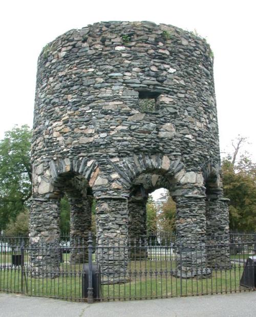
The Tower
The Newport Tower itself is a round stone tower supported by eight cylindrical columns forming stone arches, and is now about twenty eight feet high. It is located at 41′ 27 minutes north latitude on a hill in Touro Park, Newport. Its origin is uncertain and claims range from Celts, Irish, Templars, Norse, Portuguese, and Chinese to of course the early settlers of Newport.
The windmill is mentioned in the 1677 will of the Governor of Rhode Island, Benedict Arnold, who wrote of his “stonebuilt-windmill.” John Hull, a contemporary of Arnold, observed the Arnold windmill also in 1665 (Diaries of John Hull, 1847,Transactions of the American Antiquarian Society, pp 208,213,218, cited in Kuhlmann 1929:5). Hull goes on to state that Arnold built the tower to resemble a windmill he had know back home in England. This is the Chesterton Windmill in Warwickshire, which although different in style is a stone windmill built on columns, and although the columns are square and have capitals, they look very much alike. It used to be argued that it was originally built as an observatory, but recent work on the Chesterton estate records has confirmed it as a windmill (Wise 1994).
The proponents of an earlier construction have many arguments that I will not attempt to deal with in this short article, eg architectural features, the fireplace in the 2nd floor (although there are plenty of examples of early windmills with fireplaces), measurements, etc. Those arguing for its being of colonial origin rest their arguments partially on the documentary evidence but also on archaeological evidence and radio carbon dating (both of course disputed by the first group). This article, however, concentrates on the specific claim that the tower is mentioned in a 1632 document, in other words that it was already in existence seven years before Newport was settled. The claim made by Frederick J Pohl (not the science fiction writer) was that a petition and land grant made in 1632 referenced a round stone tower supposedly located at Newport, Rhode Island.
The Petition
Some time ago I had to go to Heathrow to pick up my daughter and found time to visit the Public Records Office in Kew, where I read and copied the two documents in question. The first is a petition by Sir John Lawrence and others to King Charles asking for a grant of land. This is often referred to as the ‘Plowden Petition’ as it was on behalf of a Sir Edmund Plowden, an English Catholic with an Irish knighthood (and later an Irish peerage and the title of Earl Palatine). The second document is much longer and harder to read, and is called the “Commodities of the Island called Manati or Long Island within the Continent of Virginia”. This describes resources to be found in the land described, proposals for their use, proposals for the types and numbers of settlers, etc.
The only mention of the tower is in the ‘commodities’ document, which states:
| 27: So that 30 idle men as soldiers or gent be resident in a rownd stone towre and by tornes to trade with the savages and to keep their ordinance and arms neat. |
There are two issues here. Is this a statement about an existing tower, and, more importantly, what is the location in question?
Boland (Boland) writes about Pohl’s article, adding that “as Pohl has noted, if it were a ‘commodity’ to be built in the future, it would not be listed in the 29 paragraphs at all. These paragraphs list only existing ‘commodities’ – advantages to be had immediately on settling in New Albion.”
However, Para 28 starts:
| The partners are willing to maintain [?] Governor [?] and 2 men — the rest is difficult to read but is clearly about maintaining 25 soldiers and 25 mariners to trade with the Indians. In other words, it is not about existing ‘commodities’. Other ‘commodities’ statements refer to arrangements for a governor, others to the possible earnings of fishermen, others to the numbers of types of settlers to be ‘provided’ (some were to be slaves, for instance). In addition it makes specific proposals for financing housing and fortifications in the first year and general proposals for boats, mills and ship-building. The document also mentions “a race of buffaloes which will be ridden and brought to plowe and be milked.” It thus mentions existing, future, and fanciful ‘commodities.’ |
Thus it is, in my opinion, impossible to say whether when it says ‘a rownd stone towre’ that it is referring to an existing tower or one to be built – of course, if it had said ‘the rownd stone towre’ it would be clear what was meant.
The next question is the location of the land requested. A transcription of the first part of the petition was provided for me by Brian Scott, who notes:
| “Here’s a transcription. Square brackets indicate superscriptions. Angle brackets, which I believe occur only once, indicate expansion of a standard scribal abbreviation. I’ve separated the lines for ease in matching the transcription to the original. I’ve omitted a couple of scribal marks — horizontal strokes over letters, and arcs with tickmarks — that probably don’t have any significance beyond ornamentation. I did this in some haste, and there might be one or two errors, but this is a very straightforward hand, so I don’t expect many. (It’s a mixture of secretary and italic rather characteristic of the period, and I’ve read quite a bit of it at one time or another.)” (Editor’s note: the line breaks coincide with the original text.) |
| To the Kings most Excellent Ma:[tie] The humble petiton of S:[r] John Lawrence K:[t] C Barronett, Sir Edmund Plowden K:[t] S:[r] Boyer Worsley K:[t] John Trusler Roger Pack William Inwood, Tho: Ryebread Charles Barret, & ~~~ George Noble, Adventurers./Sheweth That whereas there is a remoate place w[th]in the Confines of Virginia some 150 myles Northwards from the Savages, & James Citty w[th]out the bay of Chisapeak and a conuenient Isle there to be inhabited called Manitie, or long Isle in 39 degrees of lattitude, and within the bounds of Virginia abutting on the Ocean Eastwards 18 myles and of the Continent Westwards neere Dellaware Baye. and not formerly graunted, And are willing now att their only coste, and chardges to adventure, plant, and settle there 300 inhabitants for the ma= king of Wine, Saulte, and Iron, ffishing of Sturgeon, & Mullet, and for Cattle, and Corne for the Coloney and for the Yearely building of Shipping there with all Materialls for Yo[r] Ma:[ties] service, All [th]is is to be done w[th]out any chardge to Yo[r] Ma:[tie]/ att the only costs of the adventurers, and w[th] the haszard of Yo[r] said subiets liues and fortunes: Who humbly request only Yo[r] Ma:[ties] Royall Proteccon w[th] a fitting Pattent and power to enable them to gouerne and order their Planters and servaunts and with a supply of Victualls fro~ Ireland being much nearer, Cheaper, and safer sailing then from hence. Humbly beseeching Yo[r] most Excellent Ma:[tie]/ to com~aund the S[d]: Chaun= celor of Ireland to make to Yo[r] subiects y[e] Adventurers, a Pattent und[r] Yo[r] Seale of Ireland of the saied Isle and 30 myles square of the Coste next adioyneing to be erected into a County Palatine called Syon to be held of yo[r] Ma:[ties] Crown & of Ireland w[th]out appeale or sub= ieccon to the Governour, or Company of Virginia, and reserving y[e] 5:[th] of all Royall Mynes, and w[th] the like title, dignity and priuiledges to S[r] Edmund Plowden there as was graunted to S:[r] George Caluert K:[t] in Newfound land by Yo[r] Ma:[ties] Royall father : And with y[e] vsuall grants and priuiledges to other Coloneys, and w[th] power for y[e] supplyinge of the saied Coloney by licence of the Lord Deputy Presi= dent or Lords Justices to transpte thence Corne, Cattle, and Victu= alls, and condemnd, or repriued Malefactors, and Vacabonds at Yo[r] Ma:[ties] price, and Wages for necessary Artificers././. And Yo[r] Subiects shall euer pray for yo[r] Ma:[tie]././. |
| And there’s the problem with the Newport Tower claim. The petition says that this ‘county palatine’ is to include the island in question and some of the adjoining continent, and is at 39 degrees latitude and 150 miles north of James City. Newport is at 41.27 degrees latitude and much more than 150 miles north of James City. The area in the petition is the area of the Delaware/Maryland peninsula, and the tower in the ‘commodities’ document, whether proposed or existing, is not in Rhode Island. Shortly after this Plowden revised his petition, renaming the island ‘Isle Plowden’, increasing the number of prospective settlers, changing the name of the colony to New Albion and asking for a grant 120 miles to a side to include all other small islands between 39 and 40 degrees latitude. A patent was issued on July 24, 1632, although the charter was not forthcoming until 1634. This was a feudal charter held by Plowden by knight service of Charles I’s Irish crown (which meant the king could profit from it), allowing Plowden to grant titles, etc. which he liberally did (creating one of his sons ‘High Admiral and Baron of Roymount’). However, nothing came of it. Plowden did not leave for New Albion until 1642, spending his time in lawsuits with tenants, creditors, debtors and his wife while Swedes were busy colonising along the Delaware River. Rather than go to New Albion, in fact, he went to Virginia. An attempt to go to New Albion was then met with mutiny, and that was the end of Plowden’s only known attempt to settle the land he had been granted. He spent the rest of his life (he died in 1859) in lawsuits and conflict with his family. A copy of the original petition can be found at http://www.ramtops.co.uk/petition.html. And excerpts from an article on the charter (Carter and Lewis 1959) here: http://www.ramtops.co.uk/charter.html. References Barrett, J. (ed.) (2004), Contact, Continuity, and Collapse: The Norse Colonization of the North Atlantic. Turnhout: Brepols Kuhlman, Charles B. (1929) The Development of the Flour-milling Industry in the United States. Boston & New York: Houghton Mifflin Company. Pohl, Frederick J. (1945) “Was the Newport Tower Standing in 1632?” New England Quarterly 18 (December 1945): 501-506. Wise, Philip J, (1994), “New Evidence for the Building of Chesterton Windmill,” Warwickshire History (Winter 1994/95), vol. IX no. 4, pp. 159-161. Seaver, Kirsten A. (2004), Maps, Myths, and Men: The Story of the Vinland Map, Stanford University Press, Stanford Further Reading For a review of the history and archaeology of the Newport Tower, see: Hattendorf, Ingrid M. “From the Collection: William S. Godfrey’s Old Stone Mill Archaeological Collection.” Newport History: Journal of the Newport Historical Society 68, part 2, no. 235 (1997): 109-111. Heinemeier, J.; Högne Jungner: A Pre-Columbian origin for the Newport Tower can (still) almost certainly be excluded: a reply to professor Andre J. de Bethune. J. of the Newport Historical Society 70, 55-59 (2000). Hertz, Johs. “Round Church or Windmill? New Light on the Newport Tower.” Newport History: Journal of the Newport Historical Society 68, part 2, no. 235 (1997): 55-91. *Pages 92-97 include an appendix: Carbon-14 dating of the Newport Tower. |