From KMT Vol. 5, No. 2, Summer 1994, pp 70-4.
Reproduced with permission.
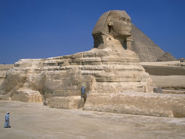
In the 1992 summer issue of KMT, American geologist Robert M. Schoch put forward the highly controversial proposition that the Great Sphinx of Giza and the adjacent Valley and Sphinx temples do not date, as currently believed by Egyptologists, from the reign of King Khafre of the Fourth Dynasty (ca. 2500 B.C.). [1] He maintained that they were originally built prior to 5000 B.C. (and possibly before 9000 B.C.), with some renovation work performed during the Old Kingdom.
INTRODUCTION
This idea was originally advocated by John Anthony West, an American self-proclaimed “independent Egyptologist,” who enlisted Dr. Schoch to develop the supporting evidence. [2] Unlike West, Schoch is an established scholar with laudable credentials, and so his views cannot be summarily dismissed. The problem with his arguments is that they are strictly geological in nature and are not easily refuted by archaeologists. It is useful, therefore, for a geologist, such as myself, to review his observations and see if they are amenable to an alternative interpretation and one more consistent with the archaeological orthodoxy.
WEATHERING PATTERNS
Schoch’s principal evidence for a pre-Old Kingdom age for the sphinx and adjacent temples is the weathering patterns which he has observed at Giza. He attributes the “rolling and undulating vertical profile” seen on the limestone body of the Sphinx and – to a greater degree – on the walls of the surrounding enclosure to “precipitation-induced weathering” (i.e., rainfall and surface runoff).
The alternating protruding and recessed beds in the profiles correspond to normal and marly limestones, respectively. The latter are richer in non-carbonate materials (quartz sand and silt, and clay minerals), [3] and these make the rock deteriorate more rapidly in the presence of water.
Dr. Schoch contrasts this style of weathering with the “wind-induced weathering” (more correctly, “wind erosion”) seen on the exteriors of
| Old Kingdom tombs and structures south and west of the Sphinx. |
He observed that the original flat vertical surfaces are largely preserved:
| but the softer, less competent layers of rock have been picked out by wind and sand abrasion. |
Schoch does not identify the specific sites he is referring to and this makes it difficult to evaluate his observations. His KMT article, however, does include a photograph of one of the tombs he observed, and its exterior exhibits the requisite flat profile. According to American archaeologist and Giza Plateau expert Mark Lehner, this is the Tomb of Debehen (Fourth Dynasty), located in the Khufu Quarry, just below the southeast comer of the Khafre pyramid (at an elevation of about 63.0 meters above sea level). [4]
Schoch maintains that the more pronounced weathering seen on and around the Sphinx could only have been produced prior to 5000 B.C., when Egypt was receiving plentiful rainfall.
I have no objections to his descriptions of weathering patterns or his recognition of wind erosion. We disagree, however, over his interpretation of precipitation-induced weathering. Schoch erred, in my opinion, by not fully considering all the factors contributing to the deterioration of limestone on the Giza Plateau. Although abundant rainfall and runoff probably can produce the kind of weathering profiles seen in the area of the Sphinx, these profiles can be equally well explained as a post-Old Kingdom development resulting from the periodic wetting of the limestone by a water-saturated sand cover.
The Old Kingdom rock-cut tombs are higher and drier than the Sphinx area, and so would have suffered mainly from wind erosion. During most of their history, the Sphinx and adjacent temples have been buried under wind-blown sand. This highly porous and permeable sediment would have soaked up and retained rain and Nile flood-waters, thus keeping the buried limestone blocks and bedrock wet for long periods (up to a few months at a time, depending on the magnitude of the rainfall or flood event).
During recent excavations of the Sphinx enclosure, for example, the accumulated sand was found to be:
| completely soaked with water a few inches below the surface,” with “the bedrock in contact with the sand [also] …soaked with water. [5] |
The lower few meters of the Sphinx enclosure and the lower several meters of the temples would have suffered the most from a wet sand-cover. Accelerated weathering, especially of the marly limestones, would result from clay expansion during wetting, and salt (halite and gypsum) precipitation during drying.
The floor of the Sphinx enclosure is 19.9 to 20.2 meters above sea level and lies near the base of the Giza Plateau. The walls of the enclosure and the top of the Sphinx’s back rise about another five and ten meters, respectively, above the floor. The bases of the Valley and Sphinx temples have elevations between 17.0 and 17.5 meters. The normal Nile-flood maximum at the Roda Nilometer near Cairo has ranged between 19.0 and 19.5 meters above sea level this century, with exceptional floods reaching elevations of 20.3 meters in 1938 and 21.4 meters in 1874. [6] During the past two centuries, there have been numerous reports of flood waters reaching the base of the Giza Plateau. [7]
Although the Sphinx and associated temples are now within the upper limits of the modern flood range, they were not during the Old Kingdom, because flood levels have risen progressively over time, due to the subsequent aggradation of the Nile River channel. In the vicinity of Cairo, this aggradation has been four to five meters over the last 4,500 years (i.e., on average, about ten centimeters per century). [8] It seems likely that – during at least the last one or two millennia – these monuments were wetted by flood waters on innumerable occasions. Capillary forces would have carried the water another one to two meters upward into the sand cover and limestone.
Rainfall in Cairo this century has typically varied between 2.5 and 3.5 centimeters per year. [9] Much of the rain is delivered by infrequent-but-intense storms. Under these conditions, most of the water will infiltrate the fractured limestone bedrock and sand cover quicker than it can evaporate. Exceptional storms may produce ground-water flows – and perhaps even surface runoff – that would be directed toward the Sphinx from the Khufu pyramid by the southeastward-dipping (at five-ten degrees) [10] limestone beds and ground surface. All indications are that the average rainfall has not changed significantly since the Old Kingdom, except for brief intervals.
OTHER EVIDENCE (1) Mud-brick Mastabas at Sakkara:
As further evidence that weathering of the Sphinx must predate the Old Kingdom, Robert Schoch claims that the First Dynasty mud-brick mastabas at Sakkara show little of the precipitation-induced weathering that he says affected the Sphinx. These structures are poorly preserved and so it is not clear why he believes they look less weathered. In any case, I think a more-likely explanation for the different degrees of deterioration (if real) is that the mastabas are high and dry on the desert plateau and so, unlike the Sphinx, have suffered mainly from wind erosion.
(2) Granite Facing on the Valley Temple:
In describing the blocks of pink Aswan granite that originally veneered the limestone walls of the Valley Temple, Dr. Schoch observed that:
| in places the backs of the granite blocks were cut in irregular, undulating patterns so that they complemented or matched the irregular weathering patterns on the limestone blocks. |
He concludes from this observation that the backs of the granite facing-blocks, which he agrees date from the Old Kingdom, were carved so as to fit the deeply weathered, pre-5000 B.C. limestone core-blocks.
Much of the granite facing on this temple was reconstructed during excavations in the early part of this century, and so it is not clear that Schoch was looking at an original feature. Assuming he was, however, there is once again a more sensible interpretation for his observation. It is well known that the hidden sides of construction blocks, especially the harder ones like granite, were left unworked by the ancient Egyptians. I suggest, therefore, that it was the softer limestone that was carved during the Old Kingdom to fit the irregularly finished granite blocks, rather than vice versa.
(3) Limestone Durability:
It has been observed that there is a generally increasing durability (due to increasing pore size) upwards in the limestone of the Sphinx enclosure. [11] I agree with Dr. Schoch that this may be a result of pre-5000 B.C. precipitation-induced weathering, in that the variation in porosity is consistent with leaching by downward infiltrating rainwater. This and other paleokarst features mentioned by him, however, say nothing about the age of the Sphinx because they could have predated the sculpting of this monument.
(4) Limestone Stratigraphy:
Dr. Schoch claims that the Old Kingdom rock-cut tombs on the Giza Plateau are “carved from the same sequence of limestones” as the Sphinx, and from this implies that artificial limestone surfaces in both areas should have weathered similarly, if they were cut at the same time. The fact that they have weathered differently, he asserts, is evidence of their different ages.
The limestone beds are all certainly from the same geologic formation (the Mokattam), but the easily weathered, marly beds in the Sphinx enclosure appear to be lower in the stratigraphic section than the beds in which the tombs are cut. [12] Thus, the tomb exteriors may be less weathered because they are composed of more-resistant limestone and not because they are younger. More field work is need to evaluate this possibility.
(5) Seismic Profiles:
Dr. Schoch interprets seismic profiles made on all sides of the Sphinx as indicating that a zone of weathered limestone exists below the floor of the enclosure – to a depth of 1.8 to 2.5 meters on the east (front), north and south, and 1.2 meters on the west (back). He claims the limestone began weathering when the enclosure was first excavated and that the shallower weathering-zone at the back of the monument indicates that the rear portion of the Sphinx was carved during the Old Kingdom, at least 2,500 years after the front and sides were carved.
There are several problems with Schoch’s interpretation. The first is his belief that the low-velocity layer just below the surface is the result of weathering. This is merely an assumption on his part. It may instead be a reflection of the original depositional character of the limestone. The lower portions of the Sphinx and enclosure walls – and the bedrock underneath to a depth of a few meters – consist of a layer of limestone which Thomas Aigner has called the “shoal reef” facies of the Mokattam Formation. [13] Aigner described the layer as consisting of:
| isolated patches ( [up] to a few meters in diameter) of coral colonies that float in a variable matrix of … reef debris, |
with the coral colonies especially abundant in the upper part of the layer. The top of this layer, which is well exposed at the base of the enclosure walls, is a hummocky surface with up to one meter of relief. [14]
It may well be that it is this zone of coral colonies identified by Aigner which Dr. Schoch has interpreted as weathered limestone in his seismic profiles. The base of this zone shows a hummocky relief in the profiles that is identical in scale to that seen at the top of the shoal-reef facies. Schoch interprets the higher-velocity zone in the lower part of the profiles as “sound limestone.” Most likely what he is actually seeing is the less-porous “nummulite bank” facies of the Mokattam Formation. [15] The southeast dip of the limestone would cause the shoal-reef facies to drop in elevation from west to east across the enclosure, and this could account for the increasing depth of Schoch’s weathering zone to the east.
The basis of his seismic interpretation is that weathered limestone has a lower seismic velocity because of its higher porosity. This is generally true, but in the case of Dr. Schoch’s seismic profiles it leads to a contradiction. [16] In the profiles figured in his KMT article, we see that the velocities for both the “weathered” and “sound” limestones at the back of the Sphinx (line S3) are twenty-three to twenty-eight percent lower than the corresponding layers along the sides (lines S1 and S2).
Using Schoch’s reasoning of lower velocities indicating greater weathering, we would have to conclude that the enclosure floor behind the Sphinx is more weathered and hence older, which is just the opposite of what he is claiming. The discrepancy between the seismic profiles perhaps results from an error in the preparation of line S3. [17] Picking the boundary between two velocity layers is always somewhat subjective. The consistently lower velocities for both the “weathered” and “sound” limestones in S3 suggests that the boundary between them was set too high. A lower boundary in S3 – giving the “weathered” limestone the same thickness as in S1 and S2 – would produce similar seismic velocities for all three profiles.
CONCLUDING REMARKS
The deeper weathering seen on and around the Sphinx, relative to the nearby Old Kingdom rock-cut tombs on the Giza Plateau, can be readily explained as resulting from the former’s lower elevation and prolonged burial beneath a cover of wind-blown sand that was periodically wetted by the Nile inundation and rainfall. The repeated and lengthy exposure to water of buried limestone blocks and bedrock would have resulted in their accelerated deterioration through clay expansion and salt precipitation. A pre-Old Kingdom age for these monuments is thus not required by the geological evidence.
Robert Schoch’s error was to give too little weight to the archaeological evidence supporting a Fourth Dynasty age for the Sphinx and associated temples. This blinded him, I believe, to some of the important geologic processes operating at Giza and the implausibility of his archaeological interpretations. Dr. Schoch and others like him who promote poorly supported, outlandish views about ancient Egypt need to be challenged.[18] I am, therefore, grateful to KMT for providing me with the opportunity to do so.
Notes
1. R.M. Schoch, “Redating the Great Sphinx of Giza,” KMT 3:2, 53-59, 66-70. See also his “A modern riddle of the Sphinx,” Omni (August, 1992), 46-48, 68-69.
2. Schoch’s and West’s views were featured in “The Mystery of the Sphinx,” a television documentary hosted by actor Charleton Heston and aired by NBC in fall 1993. West believes the Sphinx was carved by refugees from the lost continent of Atlantis, which was originally populated by people from the planet Mars.
3. T. Aigner, “Facies and origin of nummulitic buildups – an example from the Giza pyramids plateau,” Neues Jahrbuch Geologie und Palaeontologie Abhandlung 166 (1983), 347-368; K.L. Gauri, “Geologic study of the Sphinx,” Newsletter of the American Research Center in Egypt 127 (1984), 24-43.
4. This elevation and others at Giza were kindly provided by Dr. Mark Lehner of the Oriental Institute of the University of Chicago. I am also indebted to him for his critical review of an earlier draft of this manuscript.
5. K.L. Gauri, G.C. Holdren and W.C. Vaughan, “Cleaning efflorescences from masonry,” J.R. Clifton, ed., Cleaning stone and masonry (Philadelphia, 1986), 3-13; see 4-5.
6. W. Popper, “The Cairo Nilometer,” University of California Publications in Semitic Philology 12 (1951), table 22; A. Shafei, “Lake Moeris and Lahun – the great Nile control project executed by the ancient Egyptians,” Bulletin de les Société Géographique Royale de I’Égypte 33 (1960), 187-215 (see 213); R. Said, The River Nile – geology, hydrology and utilization (New York, 1993), fig. 2.27.
7. For example, see figures 13 and 14 in P. Der Manuelian, ed., “George Andrew Reisner on archaeological photography,” Journal of the American Research Center in Egypt 29 (1992), 1-34. These photographs show Nile flood waters near the base of the Giza Plateau in 1904 and 1906.
8. J. Ball, Contributions to the geography of Egypt (Cairo, 1939), 173-176; Popper (1951), 241-247; Said (1993), 59-60. Mark Lehner, in a personal communication, says that excavations indicate that the Old Kingdom floodplain was probably between 13.0 and 15.0 meters above sea level, with flood waters rising perhaps as high as 17.0 meters.
9. L.J. Sutton, Rainfall in Egypt – statistics, storms, runoff (Cairo, 1949), tables 2, 6.
10. R. Said and L. Martin, “Cairo area geological excursions notes,” F. Reilly, ed., Guidebook to the geology and archaeology of Egypt, Petroleum Exploration Society of Libya, Sixth Field Conference (1964), 107-121; Aigner (1983), 348 and fig. 11; Gauri (1984), 25 and Fig. 3A.
11. A.R. Punuru, A.N. Chowdhury, N.P. Kulshreshtha and K.L. Gauri, “Control of porosity in the durability of limestone at the Great Sphinx,” Environmental Geology and Water Science 15 (1990), 225-232.
12. Unpublished field observations of Dr. Lal Gauri, a geologist at the University of Louisville, and of Dr. Mark Lehner.
13. Aigner (1983), 355.
14. Gauri (1984), 27.
15. Aigner (1983), 349-350.
16. This was brought to my attention by Dr. Donald J. Stierman, a seismologist at the University of Toledo.
17. Dr. Stierman is also to be credited with this suggestion.
18. In recent years there has been one other, especially outrageous, example of the misuse of geological observations in interpreting ancient Egyptian monuments. I am referring to the suggestion by J. Davidovits and M. Morris that the Giza pyramids were constructed from cast-in-place concrete blocks (The Pyramids – An Engima Solved [New York, 1988]) rather than quarried blocks of natural limestone, as is currently believed by Egyptologists. For geological counter-arguments, see: R.L. Folk and D.H. Campbell, “Are the pyramids built of poured concrete blocks?,” Journal of Geological Education 40 (1992), 25-34; and J.A. Harrell and B.E. Penrod, “The great pyramid debate – evidence from the Lauer sample,” Journal of Geological Education 41 (1993), 358-363.
About the Author Dr. James A. Harrell is a professor of geology and the chairman of the Department of Geology at the University of Toledo. His Ph.D. degree in geology is from the University of Cincinnati. For the past six years, he has been conducting a topographical and petrological survey of ancient Egyptian quarries, and documenting the use of the quarry stones in monuments and sculptural works.
Webmaster Note: the database date for this article shows the date it was added to the Hall of Ma’at website and not its original publication date in KMT